
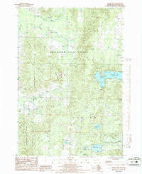
~ Thumb Lake MI topo map, 1:24000 scale, 7.5 X 7.5 Minute, Historical, 1986, updated 1986
Thumb Lake, Michigan, USGS topographic map dated 1986.
Includes geographic coordinates (latitude and longitude). This topographic map is suitable for hiking, camping, and exploring, or framing it as a wall map.
Printed on-demand using high resolution imagery, on heavy weight and acid free paper, or alternatively on a variety of synthetic materials.
Topos available on paper, Waterproof, Poly, or Tyvek. Usually shipping rolled, unless combined with other folded maps in one order.
- Product Number: USGS-5441390
- Free digital map download (high-resolution, GeoPDF): Thumb Lake, Michigan (file size: 13 MB)
- Map Size: please refer to the dimensions of the GeoPDF map above
- Weight (paper map): ca. 55 grams
- Map Type: POD USGS Topographic Map
- Map Series: HTMC
- Map Verison: Historical
- Cell ID: 71837
- Scan ID: 277393
- Imprint Year: 1986
- Woodland Tint: Yes
- Aerial Photo Year: 1983
- Edit Year: 1986
- Field Check Year: 1984
- Datum: NAD27
- Map Projection: Universal Transverse Mercator
- Provisional map: Yes
- Map published by United States Geological Survey
- Map Language: English
- Scanner Resolution: 600 dpi
- Map Cell Name: Thumb Lake
- Grid size: 7.5 X 7.5 Minute
- Date on map: 1986
- Map Scale: 1:24000
- Geographical region: Michigan, United States
Neighboring Maps:
All neighboring USGS topo maps are available for sale online at a variety of scales.
Spatial coverage:
Topo map Thumb Lake, Michigan, covers the geographical area associated the following places:
- Chandler Cemetery - Bows Lake - Hudson Lookout Tower - Heart Lake - Thumb Lake Post Office (historical) - Township of Chandler - Kuznick Creek - Hoffman Lake - Black Lake - Chandler School - Hudson Cemetery - Kidney Lake - Spring Vale Post Office (historical) - Mud Lakes - Church Camp - Township of Hudson - Licks Creek - Melrose Township Fire Department Station 2 - Howard Cemetery - Hudson Township Fire and Rescue - Thumb Lake - Thunder Mountain - Chandler Hills
- Map Area ID: AREA45.2545.125-84.875-84.75
- Northwest corner Lat/Long code: USGSNW45.25-84.875
- Northeast corner Lat/Long code: USGSNE45.25-84.75
- Southwest corner Lat/Long code: USGSSW45.125-84.875
- Southeast corner Lat/Long code: USGSSE45.125-84.75
- Northern map edge Latitude: 45.25
- Southern map edge Latitude: 45.125
- Western map edge Longitude: -84.875
- Eastern map edge Longitude: -84.75


