
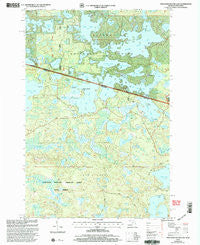
~ Thousand Island Lake MI topo map, 1:24000 scale, 7.5 X 7.5 Minute, Historical, 1999, updated 2005
Thousand Island Lake, Michigan, USGS topographic map dated 1999.
Includes geographic coordinates (latitude and longitude). This topographic map is suitable for hiking, camping, and exploring, or framing it as a wall map.
Printed on-demand using high resolution imagery, on heavy weight and acid free paper, or alternatively on a variety of synthetic materials.
Topos available on paper, Waterproof, Poly, or Tyvek. Usually shipping rolled, unless combined with other folded maps in one order.
- Product Number: USGS-5441374
- Free digital map download (high-resolution, GeoPDF): Thousand Island Lake, Michigan (file size: 16 MB)
- Map Size: please refer to the dimensions of the GeoPDF map above
- Weight (paper map): ca. 55 grams
- Map Type: POD USGS Topographic Map
- Map Series: HTMC
- Map Verison: Historical
- Cell ID: 44975
- Scan ID: 277385
- Imprint Year: 2005
- Woodland Tint: Yes
- Aerial Photo Year: 1999
- Edit Year: 1999
- Datum: NAD27
- Map Projection: Lambert Conformal Conic
- Map published by United States Forest Service
- Map Language: English
- Scanner Resolution: 600 dpi
- Map Cell Name: Thousand Island Lake
- Grid size: 7.5 X 7.5 Minute
- Date on map: 1999
- Map Scale: 1:24000
- Geographical region: Michigan, United States
Neighboring Maps:
All neighboring USGS topo maps are available for sale online at a variety of scales.
Spatial coverage:
Topo map Thousand Island Lake, Michigan, covers the geographical area associated the following places:
- Big Mosquito Lake - Dalzell Lake - Balsam Lake - Crampton Lake - Helen Lake - Hardin Lake - Coffee Lake - Cisco Lake - Cox Lake - Poor Lake - Jute Lake Lookout Tower - Dream Lake - Town of Land O'Lakes - Gray Lake - East Bay Lake - Lake of the Woods - Morley Lake - Guides Lake - McCullough Lake - Grace Lake - Jane Lake - Whitefish Creek - Belle Island - Tower Lake - Mamie Lake - Michigan Bay - Forest Lake - White Spruce Lake - Ontonagon River - Brown Lake - Thousand Island Lake - Lindsley Lake - Palmer Lake - Fishhawk Lake - Perry Lake - Bay Lake - Dutch Lake - Kickapoo Lake - Benny Lake - Plum Creek - Erwin Lake - Emeline Lake - Meadowwoods Point - Indian Point - Lac du Lune - Indian Lake - Little Mosquito Lake - Cleveland Lake - Gilbert Lake - Mule Lake - Kinwamakwad Lake - Helen Creek - Deerpath Lake - Dumbbell Lake - Midget Lake - West Bay Lake - Cedar Lake - Palmer Bay - Deadwood Lake - Big Lake - Spring Creek - Garland Springs
- Map Area ID: AREA46.2546.125-89.5-89.375
- Northwest corner Lat/Long code: USGSNW46.25-89.5
- Northeast corner Lat/Long code: USGSNE46.25-89.375
- Southwest corner Lat/Long code: USGSSW46.125-89.5
- Southeast corner Lat/Long code: USGSSE46.125-89.375
- Northern map edge Latitude: 46.25
- Southern map edge Latitude: 46.125
- Western map edge Longitude: -89.5
- Eastern map edge Longitude: -89.375


