
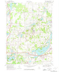
~ Kent Lake MI topo map, 1:24000 scale, 7.5 X 7.5 Minute, Historical, 1968, updated 1974
Kent Lake, Michigan, USGS topographic map dated 1968.
Includes geographic coordinates (latitude and longitude). This topographic map is suitable for hiking, camping, and exploring, or framing it as a wall map.
Printed on-demand using high resolution imagery, on heavy weight and acid free paper, or alternatively on a variety of synthetic materials.
Topos available on paper, Waterproof, Poly, or Tyvek. Usually shipping rolled, unless combined with other folded maps in one order.
- Product Number: USGS-5439610
- Free digital map download (high-resolution, GeoPDF): Kent Lake, Michigan (file size: 12 MB)
- Map Size: please refer to the dimensions of the GeoPDF map above
- Weight (paper map): ca. 55 grams
- Map Type: POD USGS Topographic Map
- Map Series: HTMC
- Map Verison: Historical
- Cell ID: 23361
- Scan ID: 276447
- Imprint Year: 1974
- Woodland Tint: Yes
- Photo Revision Year: 1973
- Aerial Photo Year: 1973
- Field Check Year: 1968
- Datum: NAD27
- Map Projection: Polyconic
- Map published by United States Geological Survey
- Map Language: English
- Scanner Resolution: 600 dpi
- Map Cell Name: Kent Lake
- Grid size: 7.5 X 7.5 Minute
- Date on map: 1968
- Map Scale: 1:24000
- Geographical region: Michigan, United States
Neighboring Maps:
All neighboring USGS topo maps are available for sale online at a variety of scales.
Spatial coverage:
Topo map Kent Lake, Michigan, covers the geographical area associated the following places:
- Honeywell Lake - Huron Clinton Metropolitan Authority Police Department - Sears Lake - Brighton Christian Church - Lake Serenity - Hartland Farms Intermediate School - Green Oak Township Fire Department Station 82 - Briggs Lake - Lyon Township Fire Department Station 1 Headquarters - Brighton District Number Eight School Historical Marker - Interchange 153 - Spencer Elementary School - Nitz Heliport - Lord of Life Lutheran Church - Kent Lake Elementary School - Pickett Lake - Camp Dearborn - Kensington Baptist Church Cemetery - West Highland Christian Academy - Kensington Post Office (historical) - Phillip Lake - Highland Montessori School - Hynes Field (historical) - Island Lake - Kent Lake - Waw Lake - Old Kensington Cemetery - Brighton Hospital - Lakes Elementary School - Pickerel Lake - Hartland Plaza Shopping Center - Woodruff Lake - Beach Lake - School Lake - Pleasant Valley Baptist Church - Brighton Cemetery - Interchange 151 - Wildwing Lake - Bird Cemetery - Interchange 150 - Long Lake - Woodruff Creek - Mott Lake - Priscilla Calkins Prior House Historical Marker - Kensington Metropolitan Park - Bitten Lake - Mystic Creek Golf Club - Lake of the Pines - Mann Creek - Lakeside Camp - Sloan Lake - The Bluffs - Rowe Lake - Rowe House Historical Marker - Covenant Orthodox Presbyterian Church - Michigan State Police District 1 Brighton Post 12 - Woodruff Farm Cemetery - Kensington Metropark Golf Course - Township of Brighton - Spanish American War Regiments Historical Marker - Moraine Lake
- Map Area ID: AREA42.62542.5-83.75-83.625
- Northwest corner Lat/Long code: USGSNW42.625-83.75
- Northeast corner Lat/Long code: USGSNE42.625-83.625
- Southwest corner Lat/Long code: USGSSW42.5-83.75
- Southeast corner Lat/Long code: USGSSE42.5-83.625
- Northern map edge Latitude: 42.625
- Southern map edge Latitude: 42.5
- Western map edge Longitude: -83.75
- Eastern map edge Longitude: -83.625


