
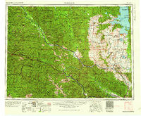
~ Wallace ID topo map, 1:250000 scale, 1 X 2 Degree, Historical, 1960
Wallace, Idaho, USGS topographic map dated 1960.
Includes geographic coordinates (latitude and longitude). This topographic map is suitable for hiking, camping, and exploring, or framing it as a wall map.
Printed on-demand using high resolution imagery, on heavy weight and acid free paper, or alternatively on a variety of synthetic materials.
Topos available on paper, Waterproof, Poly, or Tyvek. Usually shipping rolled, unless combined with other folded maps in one order.
- Product Number: USGS-5437740
- Free digital map download (high-resolution, GeoPDF): Wallace, Idaho (file size: 27 MB)
- Map Size: please refer to the dimensions of the GeoPDF map above
- Weight (paper map): ca. 55 grams
- Map Type: POD USGS Topographic Map
- Map Series: HTMC
- Map Verison: Historical
- Cell ID: 72255
- Scan ID: 239687
- Woodland Tint: Yes
- Aerial Photo Year: 1957
- Field Check Year: 1956
- Datum: Unstated
- Map Projection: Transverse Mercator
- Map published by United States Army Corps of Engineers
- Map published by United States Army
- Map Language: English
- Scanner Resolution: 600 dpi
- Map Cell Name: Wallace
- Grid size: 1 X 2 Degree
- Date on map: 1960
- Map Scale: 1:250000
- Geographical region: Idaho, United States
Neighboring Maps:
All neighboring USGS topo maps are available for sale online at a variety of scales.
Spatial coverage:
Topo map Wallace, Idaho, covers the geographical area associated the following places:
- Bogle - Ronan - Island City (historical) - Moiese - Olsons - Old Agency - Avery - Cedar Junction (historical) - Donlan - Alberton - Childs - Blackcloud - Ashleys Settlement (historical) - Lozeau - Quinns - McDonald - McCarthy - Horsecamp - Hog Heaven (historical) - Riverview Trailer Park - Jette - Hot Springs - Hopkins - Belle-Vue Court - Frenchtown - Amador (historical) - Cornwall - Kings Point - McDonalds - Lake Mary Ronan - Bunn - Plains - Post Creek - Stull - Ninemile - Saint Regis - Roland - Cabin City - Falcon - Allard (historical) - Sipes - Willow Wynn Trailer Park - Sohon - Camas - Kicking Horse - Six Mile (historical) - De Borgia - Mullan - Sunset (historical) - Camas Prairie - Oliverville - Shannonville (historical) - Sloan - Dixon - Big Arm - Spring Gulch - Eddy - Carbonate (historical) - Westfall - Golconda - White Pine - Dunham - Mountain View (historical) - Lindisfarne - Central Avenue Trailer Court - Allentown - Weeksville - Ethelton - Nuckols - Round Butte - Tammany - Hoyt - Perma - Fort Lazy Y Trailer Park - Pottsville (historical) - Mission Meadows Trailer Park - Proctor - Stetson - Buford (historical) - Agency - Borax - Wallace - Charlo - Carbon Center - Drexel - Blanchards Corner - Prichard - Pablo - Keystone - Snider - East Portal - Rocky Point - Frisco - Evaro - Soudan - Taft - Trout Creek - Saltese - Huson - Meltons
- Map Area ID: AREA4847-116-114
- Northwest corner Lat/Long code: USGSNW48-116
- Northeast corner Lat/Long code: USGSNE48-114
- Southwest corner Lat/Long code: USGSSW47-116
- Southeast corner Lat/Long code: USGSSE47-114
- Northern map edge Latitude: 48
- Southern map edge Latitude: 47
- Western map edge Longitude: -116
- Eastern map edge Longitude: -114


