
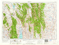
~ Preston ID topo map, 1:250000 scale, 1 X 2 Degree, Historical, 1962
Preston, Idaho, USGS topographic map dated 1962.
Includes geographic coordinates (latitude and longitude). This topographic map is suitable for hiking, camping, and exploring, or framing it as a wall map.
Printed on-demand using high resolution imagery, on heavy weight and acid free paper, or alternatively on a variety of synthetic materials.
Topos available on paper, Waterproof, Poly, or Tyvek. Usually shipping rolled, unless combined with other folded maps in one order.
- Product Number: USGS-5437720
- Free digital map download (high-resolution, GeoPDF): Preston, Idaho (file size: 22 MB)
- Map Size: please refer to the dimensions of the GeoPDF map above
- Weight (paper map): ca. 55 grams
- Map Type: POD USGS Topographic Map
- Map Series: HTMC
- Map Verison: Historical
- Cell ID: 72243
- Scan ID: 239671
- Woodland Tint: Yes
- Aerial Photo Year: 1955
- Edit Year: 1961
- Field Check Year: 1955
- Datum: Unstated
- Map Projection: Transverse Mercator
- Map published by United States Army Corps of Engineers
- Map published by United States Army
- Map Language: English
- Scanner Resolution: 600 dpi
- Map Cell Name: Preston
- Grid size: 1 X 2 Degree
- Date on map: 1962
- Map Scale: 1:250000
- Geographical region: Idaho, United States
Neighboring Maps:
All neighboring USGS topo maps are available for sale online at a variety of scales.
Spatial coverage:
Topo map Preston, Idaho, covers the geographical area associated the following places:
- Old Williamsburg (historical) - Border Junction - Merna - Alton - Riverdale - Niter - Dempsey (historical) - Winder - Lanark - Kinport - Soda Springs - Rose - Border - Chesterfield - Coulam - Cherryville - Novene - Calpet - Grace - Grover - Auburn - Afton - Dingle - Harer - Montpelier - Halfway - China Hill - Glencoe - Williamsburg (historical) - Sharon - Turnpike - Bear Lake Hot Springs - Raymond - Smoot - Franklin - Swan Lake - Dayton - Viola - Star Valley Ranch - Cokeville - Pegram - Bedford - Fish Haven - Paris - Mound Valley - Saint Charles - Nounan - Wooleys - Central - Lund - Marbleton - Geneva - Fairview - Bench - Manson - Lindsayville - Bancroft - Talmage - Lifton - Weston - Bronx - Mapleton - Telluride - Osmond - Fairview - Glendale - Alexander - Chausse - Henry - Bennington - Cleveland - Wayan - Thorenson - Hatch - Freedom - Big Piney - Bloomington - Bern - Nashville - Anderson - Daniel Junction - Georgetown - Wardboro - Banida - La Barge - Silver Star - Whitney - Lago - Egypt - Thayne - Daniel - Bear Lake Sands - Thatcher - Treasureton - Conda - Preston - Meadowville - Turnerville - Liberty - Giveout
- Map Area ID: AREA4342-112-110
- Northwest corner Lat/Long code: USGSNW43-112
- Northeast corner Lat/Long code: USGSNE43-110
- Southwest corner Lat/Long code: USGSSW42-112
- Southeast corner Lat/Long code: USGSSE42-110
- Northern map edge Latitude: 43
- Southern map edge Latitude: 42
- Western map edge Longitude: -112
- Eastern map edge Longitude: -110


