
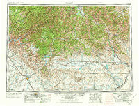
~ Hailey ID topo map, 1:250000 scale, 1 X 2 Degree, Historical, 1955, updated 1973
Hailey, Idaho, USGS topographic map dated 1955.
Includes geographic coordinates (latitude and longitude). This topographic map is suitable for hiking, camping, and exploring, or framing it as a wall map.
Printed on-demand using high resolution imagery, on heavy weight and acid free paper, or alternatively on a variety of synthetic materials.
Topos available on paper, Waterproof, Poly, or Tyvek. Usually shipping rolled, unless combined with other folded maps in one order.
- Product Number: USGS-5437682
- Free digital map download (high-resolution, GeoPDF): Hailey, Idaho (file size: 27 MB)
- Map Size: please refer to the dimensions of the GeoPDF map above
- Weight (paper map): ca. 55 grams
- Map Type: POD USGS Topographic Map
- Map Series: HTMC
- Map Verison: Historical
- Cell ID: 68812
- Scan ID: 239647
- Imprint Year: 1973
- Woodland Tint: Yes
- Aerial Photo Year: 1954
- Edit Year: 1970
- Field Check Year: 1955
- Datum: NAD27
- Map Projection: Transverse Mercator
- Map published by: Military, Other
- Map Language: English
- Scanner Resolution: 600 dpi
- Map Cell Name: Hailey
- Grid size: 1 X 2 Degree
- Date on map: 1955
- Map Scale: 1:250000
- Geographical region: Idaho, United States
Neighboring Maps:
All neighboring USGS topo maps are available for sale online at a variety of scales.
Spatial coverage:
Topo map Hailey, Idaho, covers the geographical area associated the following places:
- Tenmile Summer Home Area - Stanton Crossing - Cleft - Easley Hot Springs - Blaine - Magic Resort - Galena - Mayfield - Regina - Sebree - Barite - Richfield - Triumph - Neal (historical) - Star Ranch Summer Home Area - Rands - Bullion - Selby - Pagari - Emigrant Crossing - Macon - Placerville - Carrietown - Paradise Hot Springs - Mountain Home - New Centerville - Magic City - Broadford - Tikura - Soldier - Twin Springs - Granite - Graham (historical) - Indian Head Rock - Centerville - Cathedral Pines - Punkin Corner - Gimlet - Clarendon Hot Springs - Steamboat Rock - Featherville - Dixie - Bellevue - Burmah - Doniphan - Reclamation Village - Sun Valley - Spanish Town (historical) - Castle Rocks - Ketchum - Marley - King Hill - Picabo - Hill City - Hailey - Quartzburg - Stout Crossing - Fairfield - Atlanta - Pine - Prairie - Washington Mill - Leduc (historical) - Boulder - Sawtooth City (historical) - Gannett - Pioneerville - Alturas City (historical) - Magic - Rocky Bar - Idaho City - Elkhorn Village - Reverse
- Map Area ID: AREA4443-116-114
- Northwest corner Lat/Long code: USGSNW44-116
- Northeast corner Lat/Long code: USGSNE44-114
- Southwest corner Lat/Long code: USGSSW43-116
- Southeast corner Lat/Long code: USGSSE43-114
- Northern map edge Latitude: 44
- Southern map edge Latitude: 43
- Western map edge Longitude: -116
- Eastern map edge Longitude: -114


