
~ Dubois ID topo map, 1:250000 scale, 1 X 2 Degree, Historical, 1955, updated 1968
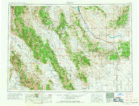
Dubois, Idaho, USGS topographic map dated 1955.
Includes geographic coordinates (latitude and longitude). This topographic map is suitable for hiking, camping, and exploring, or framing it as a wall map.
Printed on-demand using high resolution imagery, on heavy weight and acid free paper, or alternatively on a variety of synthetic materials.
Topos available on paper, Waterproof, Poly, or Tyvek. Usually shipping rolled, unless combined with other folded maps in one order.
- Product Number: USGS-5437644
- Free digital map download (high-resolution, GeoPDF): Dubois, Idaho (file size: 21 MB)
- Map Size: please refer to the dimensions of the GeoPDF map above
- Weight (paper map): ca. 55 grams
- Map Type: POD USGS Topographic Map
- Map Series: HTMC
- Map Verison: Historical
- Cell ID: 68756
- Scan ID: 239629
- Imprint Year: 1968
- Woodland Tint: Yes
- Aerial Photo Year: 1955
- Edit Year: 1962
- Field Check Year: 1955
- Datum: Unstated
- Map Projection: Transverse Mercator
- Map published by United States Army Corps of Engineers
- Map published by United States Army
- Map Language: English
- Scanner Resolution: 600 dpi
- Map Cell Name: Dubois
- Grid size: 1 X 2 Degree
- Date on map: 1955
- Map Scale: 1:250000
- Geographical region: Idaho, United States
Neighboring Maps:
All neighboring USGS topo maps are available for sale online at a variety of scales.
Spatial coverage:
Topo map Dubois, Idaho, covers the geographical area associated the following places:
- Nicholia (historical) - Chilly - Jones Crossing - Chinatown - Hahn - Dubois - Winsper - Highbridge - Lemhi - Red Rock - Clyde - Nicholia - May - Armstead (historical) - Lone Pine - Junction - Lima - Gilmore - Goldburg - Kaufman (historical) - Humphrey - Leadville - Dell - Patterson - Blue Dome - Monida - Hildreth - Lidy Hot Springs - Camas - Spencer - Dickey - Elk Bend - Old Beaver - Tendoy - Kidd - Leadore
- Map Area ID: AREA4544-114-112
- Northwest corner Lat/Long code: USGSNW45-114
- Northeast corner Lat/Long code: USGSNE45-112
- Southwest corner Lat/Long code: USGSSW44-114
- Southeast corner Lat/Long code: USGSSE44-112
- Northern map edge Latitude: 45
- Southern map edge Latitude: 44
- Western map edge Longitude: -114
- Eastern map edge Longitude: -112


