
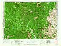
~ Challis ID topo map, 1:250000 scale, 1 X 2 Degree, Historical, 1957, updated 1964
Challis, Idaho, USGS topographic map dated 1957.
Includes geographic coordinates (latitude and longitude). This topographic map is suitable for hiking, camping, and exploring, or framing it as a wall map.
Printed on-demand using high resolution imagery, on heavy weight and acid free paper, or alternatively on a variety of synthetic materials.
Topos available on paper, Waterproof, Poly, or Tyvek. Usually shipping rolled, unless combined with other folded maps in one order.
- Product Number: USGS-5437620
- Free digital map download (high-resolution, GeoPDF): Challis, Idaho (file size: 27 MB)
- Map Size: please refer to the dimensions of the GeoPDF map above
- Weight (paper map): ca. 55 grams
- Map Type: POD USGS Topographic Map
- Map Series: HTMC
- Map Verison: Historical
- Cell ID: 68707
- Scan ID: 239616
- Imprint Year: 1964
- Woodland Tint: Yes
- Aerial Photo Year: 1957
- Edit Year: 1963
- Field Check Year: 1955
- Datum: Unstated
- Map Projection: Transverse Mercator
- Map published by United States Army Corps of Engineers
- Map published by United States Army
- Map published by United States Department of War
- Map Language: English
- Scanner Resolution: 600 dpi
- Map Cell Name: Challis
- Grid size: 1 X 2 Degree
- Date on map: 1957
- Map Scale: 1:250000
- Geographical region: Idaho, United States
Neighboring Maps:
All neighboring USGS topo maps are available for sale online at a variety of scales.
Spatial coverage:
Topo map Challis, Idaho, covers the geographical area associated the following places:
- Sunbeam - Obsidian - Midnight - Cape Horn (historical) - Torreys - Bayhorse - Custer - Shoreline Drive Summer Home Area - Grimes Pass - Robinson Bar - Lakeshore Summer Home Area - Camp Creek Summer Home Area - Kinney Point Summer Home Area - Garden Valley - Long Creek Summit Home - Bear Creek Summer Home Area - Landmark - Banner - Garden City (historical) - Forney - Casto - Stibnite - Warm Lake - Lower Stanley - Grandjean - Crouch - Clayton - Bonanza - Paradise Valley Summer Home Area - Lowman - Stanley - Challis - Yellow Pine - Crystal (historical) - Yellowjacket - Ellis - Abstein Place - Eagle Nest
- Map Area ID: AREA4544-116-114
- Northwest corner Lat/Long code: USGSNW45-116
- Northeast corner Lat/Long code: USGSNE45-114
- Southwest corner Lat/Long code: USGSSW44-116
- Southeast corner Lat/Long code: USGSSE44-114
- Northern map edge Latitude: 45
- Southern map edge Latitude: 44
- Western map edge Longitude: -116
- Eastern map edge Longitude: -114


