
~ Ashton ID topo map, 1:250000 scale, 1 X 2 Degree, Historical, 1958, updated 1958
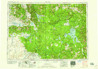
Ashton, Idaho, USGS topographic map dated 1958.
Includes geographic coordinates (latitude and longitude). This topographic map is suitable for hiking, camping, and exploring, or framing it as a wall map.
Printed on-demand using high resolution imagery, on heavy weight and acid free paper, or alternatively on a variety of synthetic materials.
Topos available on paper, Waterproof, Poly, or Tyvek. Usually shipping rolled, unless combined with other folded maps in one order.
- Product Number: USGS-5437592
- Free digital map download (high-resolution, GeoPDF): Ashton, Idaho (file size: 22 MB)
- Map Size: please refer to the dimensions of the GeoPDF map above
- Weight (paper map): ca. 55 grams
- Map Type: POD USGS Topographic Map
- Map Series: HTMC
- Map Verison: Historical
- Cell ID: 68651
- Scan ID: 239598
- Imprint Year: 1958
- Woodland Tint: Yes
- Aerial Photo Year: 1954
- Field Check Year: 1955
- Datum: Unstated
- Map Projection: Transverse Mercator
- Map published by United States Army Corps of Engineers
- Map published by United States Army
- Map Language: English
- Scanner Resolution: 600 dpi
- Map Cell Name: Ashton
- Grid size: 1 X 2 Degree
- Date on map: 1958
- Map Scale: 1:250000
- Geographical region: Idaho, United States
Neighboring Maps:
All neighboring USGS topo maps are available for sale online at a variety of scales.
Spatial coverage:
Topo map Ashton, Idaho, covers the geographical area associated the following places:
- Grahams Place - Marysville - Canyon Junction - Fossil Forest - Lakeview - Staley Springs - Lonesome Hurst Summer Home Area - Pineview - Bedstead Corner - Lakeshore Summer Home Area - Grayling - Mammoth - Warm River - Kilgore - Lake - Riverside - Jenkins Will - Yanceys - Last Chance - Lakeview - Cliff Lake - Railroad Summer Home Area - Missouri Flats (historical) - Lake - Horse Butte Acres Trailer Court - Idmon - Island Park - Sarilda - Squirrel - Flat Rock - Three River Junction - Eighteenmile - Gerrit - Box Canyon - Bannock Ford - Lodi (historical) - Rea - West Thumb - Ashton - Buffalo Ford - Schusters Place - West Yellowstone - Trude - Big Springs - Canyon Village - Tower Junction - Greentimber (historical) - Grainville - Ora - Corette - Romsett Summer Home Area - Eccles - Soda Butte (historical)
- Map Area ID: AREA4544-112-110
- Northwest corner Lat/Long code: USGSNW45-112
- Northeast corner Lat/Long code: USGSNE45-110
- Southwest corner Lat/Long code: USGSSW44-112
- Southeast corner Lat/Long code: USGSSE44-110
- Northern map edge Latitude: 45
- Southern map edge Latitude: 44
- Western map edge Longitude: -112
- Eastern map edge Longitude: -110


