
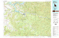
~ St Maries ID topo map, 1:100000 scale, 30 X 60 Minute, Historical, 1981, updated 1981
St Maries, Idaho, USGS topographic map dated 1981.
Includes geographic coordinates (latitude and longitude). This topographic map is suitable for hiking, camping, and exploring, or framing it as a wall map.
Printed on-demand using high resolution imagery, on heavy weight and acid free paper, or alternatively on a variety of synthetic materials.
Topos available on paper, Waterproof, Poly, or Tyvek. Usually shipping rolled, unless combined with other folded maps in one order.
- Product Number: USGS-5437162
- Free digital map download (high-resolution, GeoPDF): St Maries, Idaho (file size: 37 MB)
- Map Size: please refer to the dimensions of the GeoPDF map above
- Weight (paper map): ca. 55 grams
- Map Type: POD USGS Topographic Map
- Map Series: HTMC
- Map Verison: Historical
- Cell ID: 68284
- Scan ID: 239428
- Imprint Year: 1981
- Woodland Tint: Yes
- Visual Version Number: 2
- Aerial Photo Year: 1977
- Edit Year: 1981
- Datum: NAD27
- Map Projection: Universal Transverse Mercator
- Map published by United States Geological Survey
- Map Language: English
- Scanner Resolution: 600 dpi
- Map Cell Name: Saint Maries
- Grid size: 30 X 60 Minute
- Date on map: 1981
- Map Scale: 1:100000
- Geographical region: Idaho, United States
Neighboring Maps:
All neighboring USGS topo maps are available for sale online at a variety of scales.
Spatial coverage:
Topo map St Maries, Idaho, covers the geographical area associated the following places:
- Calder - Rover - Mountain Home (historical) - Clarkia - Flat Creek - Omega - North South Ski Bowl - Mowry - Emerald Creek - Smaq'wqn Hill - Medimont - Erlmo - Worley - Silvertip Landing - Plummer Junction - Renfrew - Wayland - Conkling Park - Sanders - Herrick - Alder Creek - Lacon - Emida - Plummer - Springston - Parkline - De Smet - Cardwell - Tyson Creek Station - Marble Creek - Saint Joe - Milltown - Benewah - Harrison - Tensed - Masonia (historical) - Pocono - Riverdale - Chł'ach'alqw Landing - Hawleys Landing - Lotus - Ramsdell - Chat'u'washa'lqs Bluff - Santa - Saint Maries - Meadowhurst - Cora - Chatcolet - Rocky Point - Fernwood - Mashburn - Pedee - Mozart
- Map Area ID: AREA47.547-117-116
- Northwest corner Lat/Long code: USGSNW47.5-117
- Northeast corner Lat/Long code: USGSNE47.5-116
- Southwest corner Lat/Long code: USGSSW47-117
- Southeast corner Lat/Long code: USGSSE47-116
- Northern map edge Latitude: 47.5
- Southern map edge Latitude: 47
- Western map edge Longitude: -117
- Eastern map edge Longitude: -116


