
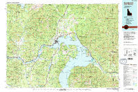
~ Sandpoint ID topo map, 1:100000 scale, 30 X 60 Minute, Historical, 1984, updated 1984
Sandpoint, Idaho, USGS topographic map dated 1984.
Includes geographic coordinates (latitude and longitude). This topographic map is suitable for hiking, camping, and exploring, or framing it as a wall map.
Printed on-demand using high resolution imagery, on heavy weight and acid free paper, or alternatively on a variety of synthetic materials.
Topos available on paper, Waterproof, Poly, or Tyvek. Usually shipping rolled, unless combined with other folded maps in one order.
- Product Number: USGS-5437154
- Free digital map download (high-resolution, GeoPDF): Sandpoint, Idaho (file size: 36 MB)
- Map Size: please refer to the dimensions of the GeoPDF map above
- Weight (paper map): ca. 55 grams
- Map Type: POD USGS Topographic Map
- Map Series: HTMC
- Map Verison: Historical
- Cell ID: 68316
- Scan ID: 239423
- Imprint Year: 1984
- Woodland Tint: Yes
- Visual Version Number: 2
- Aerial Photo Year: 1981
- Edit Year: 1984
- Datum: NAD27
- Map Projection: Universal Transverse Mercator
- Map published by United States Geological Survey
- Map Language: English
- Scanner Resolution: 600 dpi
- Map Cell Name: Sandpoint
- Grid size: 30 X 60 Minute
- Date on map: 1984
- Map Scale: 1:100000
- Geographical region: Idaho, United States
Neighboring Maps:
All neighboring USGS topo maps are available for sale online at a variety of scales.
Spatial coverage:
Topo map Sandpoint, Idaho, covers the geographical area associated the following places:
- Cedar (historical) - Careywood - Sherwood Beach - Granite - Newman - Seneacquoteen - Vay - Cabinet - Sunnyside - Colburn - Dickensheet Junction - Glengary - Dufort - Garfield - Coleman - Laclede - Priest River - Sawyer - Granite - Hope - Elmira - Selle - Ponderay - Denton - Kootenai - Blacktail - Morton - Blanchard - Edgemere - Clark Fork - Outlet Bay - Cocolalla - Culver - Kelso - East Hope - Dover - Sandpoint - Sagle - Broten - Algoma - Bronx - Talache Landing - Cedar Creek - Clagstone - Lignite - Evans Landing - Boyer - Trestle Creek - Riverside (historical) - Westmond - Harlem - Coolin - Samuels - Wrencoe - Thama - Talache - Oden - Four Corners
- Map Area ID: AREA48.548-117-116
- Northwest corner Lat/Long code: USGSNW48.5-117
- Northeast corner Lat/Long code: USGSNE48.5-116
- Southwest corner Lat/Long code: USGSSW48-117
- Southeast corner Lat/Long code: USGSSE48-116
- Northern map edge Latitude: 48.5
- Southern map edge Latitude: 48
- Western map edge Longitude: -117
- Eastern map edge Longitude: -116


