
~ Rogerson ID topo map, 1:100000 scale, 30 X 60 Minute, Historical, 1992, updated 1992
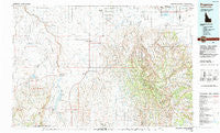
Rogerson, Idaho, USGS topographic map dated 1992.
Includes geographic coordinates (latitude and longitude). This topographic map is suitable for hiking, camping, and exploring, or framing it as a wall map.
Printed on-demand using high resolution imagery, on heavy weight and acid free paper, or alternatively on a variety of synthetic materials.
Topos available on paper, Waterproof, Poly, or Tyvek. Usually shipping rolled, unless combined with other folded maps in one order.
- Product Number: USGS-5437148
- Free digital map download (high-resolution, GeoPDF): Rogerson, Idaho (file size: 28 MB)
- Map Size: please refer to the dimensions of the GeoPDF map above
- Weight (paper map): ca. 55 grams
- Map Type: POD USGS Topographic Map
- Map Series: HTMC
- Map Verison: Historical
- Cell ID: 68255
- Scan ID: 239419
- Imprint Year: 1992
- Woodland Tint: Yes
- Aerial Photo Year: 1984
- Edit Year: 1992
- Datum: NAD27
- Map Projection: Universal Transverse Mercator
- Map published by United States Geological Survey
- Map Language: English
- Scanner Resolution: 600 dpi
- Map Cell Name: Rogerson
- Grid size: 30 X 60 Minute
- Date on map: 1992
- Map Scale: 1:100000
- Geographical region: Idaho, United States
Neighboring Maps:
All neighboring USGS topo maps are available for sale online at a variety of scales.
Spatial coverage:
Topo map Rogerson, Idaho, covers the geographical area associated the following places:
- Anderson Place - Bergstrom Place - Player Place - Roseworth - Rock Creek - Harrell Place - Threemile Crossing - Amsterdam - Rock House Place - Garrard Ranch - Hollister - Hoelzle Place - Murtaugh - Berger - Indian Jim Place - Rogerson - May Place - Hand Place - Striker - Artesian City - Iversons - Duncan Place - Vosburg Place
- Map Area ID: AREA42.542-115-114
- Northwest corner Lat/Long code: USGSNW42.5-115
- Northeast corner Lat/Long code: USGSNE42.5-114
- Southwest corner Lat/Long code: USGSSW42-115
- Southeast corner Lat/Long code: USGSSE42-114
- Northern map edge Latitude: 42.5
- Southern map edge Latitude: 42
- Western map edge Longitude: -115
- Eastern map edge Longitude: -114


