
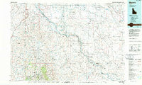
~ Murphy ID topo map, 1:100000 scale, 30 X 60 Minute, Historical, 1986, updated 1986
Murphy, Idaho, USGS topographic map dated 1986.
Includes geographic coordinates (latitude and longitude). This topographic map is suitable for hiking, camping, and exploring, or framing it as a wall map.
Printed on-demand using high resolution imagery, on heavy weight and acid free paper, or alternatively on a variety of synthetic materials.
Topos available on paper, Waterproof, Poly, or Tyvek. Usually shipping rolled, unless combined with other folded maps in one order.
- Product Number: USGS-5437122
- Free digital map download (high-resolution, GeoPDF): Murphy, Idaho (file size: 25 MB)
- Map Size: please refer to the dimensions of the GeoPDF map above
- Weight (paper map): ca. 55 grams
- Map Type: POD USGS Topographic Map
- Map Series: HTMC
- Map Verison: Historical
- Cell ID: 68019
- Scan ID: 239399
- Imprint Year: 1986
- Woodland Tint: Yes
- Aerial Photo Year: 1981
- Edit Year: 1986
- Datum: NAD27
- Map Projection: Universal Transverse Mercator
- Map published by United States Geological Survey
- Map Language: English
- Scanner Resolution: 600 dpi
- Map Cell Name: Murphy
- Grid size: 30 X 60 Minute
- Date on map: 1986
- Map Scale: 1:100000
- Geographical region: Idaho, United States
Neighboring Maps:
All neighboring USGS topo maps are available for sale online at a variety of scales.
Spatial coverage:
Topo map Murphy, Idaho, covers the geographical area associated the following places:
- Little Sugar Loaf - Silver City - Wilson - Democrat - Bowmont - Slacks Corner - Dewey - Sinker (historical) - Oreana - De Lamar - Morgan Place - Guffey - Warrens - Swan Falls - Melba - Mora - Telegraph Hill - Walters Ferry - Pleasant Valley - Givens Hot Springs - Owyhee - Blacks (historical) - Reynolds - Kuna - Blacks Creek - Orchard - Leone - Petersons Crossing - Sands (historical) - Murphy - Westma
- Map Area ID: AREA43.543-117-116
- Northwest corner Lat/Long code: USGSNW43.5-117
- Northeast corner Lat/Long code: USGSNE43.5-116
- Southwest corner Lat/Long code: USGSSW43-117
- Southeast corner Lat/Long code: USGSSE43-116
- Northern map edge Latitude: 43.5
- Southern map edge Latitude: 43
- Western map edge Longitude: -117
- Eastern map edge Longitude: -116


