
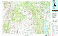
~ McCall ID topo map, 1:100000 scale, 30 X 60 Minute, Historical, 1980, updated 1993
McCall, Idaho, USGS topographic map dated 1980.
Includes geographic coordinates (latitude and longitude). This topographic map is suitable for hiking, camping, and exploring, or framing it as a wall map.
Printed on-demand using high resolution imagery, on heavy weight and acid free paper, or alternatively on a variety of synthetic materials.
Topos available on paper, Waterproof, Poly, or Tyvek. Usually shipping rolled, unless combined with other folded maps in one order.
- Product Number: USGS-5437116
- Free digital map download (high-resolution, GeoPDF): McCall, Idaho (file size: 29 MB)
- Map Size: please refer to the dimensions of the GeoPDF map above
- Weight (paper map): ca. 55 grams
- Map Type: POD USGS Topographic Map
- Map Series: HTMC
- Map Verison: Historical
- Cell ID: 67924
- Scan ID: 239395
- Imprint Year: 1993
- Woodland Tint: Yes
- Visual Version Number: 2
- Photo Inspection Year: 1990
- Aerial Photo Year: 1990
- Edit Year: 1980
- Datum: NAD27
- Map Projection: Universal Transverse Mercator
- Map published by United States Geological Survey
- Map Language: English
- Scanner Resolution: 600 dpi
- Map Cell Name: McCall
- Grid size: 30 X 60 Minute
- Date on map: 1980
- Map Scale: 1:100000
- Geographical region: Idaho, United States
Neighboring Maps:
All neighboring USGS topo maps are available for sale online at a variety of scales.
Spatial coverage:
Topo map McCall, Idaho, covers the geographical area associated the following places:
- Hillsdale (historical) - Wildhorse - Starkey - Cambridge - Woodland - Roseberry - Pine Creek - Brownlee - Meadows - Alpine - Pine Ridge - Beer Bottle Crossing - Elo (historical) - Lake Fork - Spink - Hoover - Council - Salubria - Cascade - Old Fort - Fruitvale - Heath (historical) - Donnelly - Heath - Dale (historical) - Stevens - Oxbow - MacGregor (historical) - Oxbow (historical) - Tamarack - Evergreen - McCall - Norwood - Indian Valley - Arling - Mesa - New Meadows - Bacon - Rubicon - Glendale - Goodrich - Archabal
- Map Area ID: AREA4544.5-117-116
- Northwest corner Lat/Long code: USGSNW45-117
- Northeast corner Lat/Long code: USGSNE45-116
- Southwest corner Lat/Long code: USGSSW44.5-117
- Southeast corner Lat/Long code: USGSSE44.5-116
- Northern map edge Latitude: 45
- Southern map edge Latitude: 44.5
- Western map edge Longitude: -117
- Eastern map edge Longitude: -116


