
~ Coeur D Alene ID topo map, 1:100000 scale, 30 X 60 Minute, Historical, 1987, updated 1987
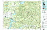
Coeur D Alene, Idaho, USGS topographic map dated 1987.
Includes geographic coordinates (latitude and longitude). This topographic map is suitable for hiking, camping, and exploring, or framing it as a wall map.
Printed on-demand using high resolution imagery, on heavy weight and acid free paper, or alternatively on a variety of synthetic materials.
Topos available on paper, Waterproof, Poly, or Tyvek. Usually shipping rolled, unless combined with other folded maps in one order.
- Product Number: USGS-5437086
- Free digital map download (high-resolution, GeoPDF): Coeur D Alene, Idaho (file size: 36 MB)
- Map Size: please refer to the dimensions of the GeoPDF map above
- Weight (paper map): ca. 55 grams
- Map Type: POD USGS Topographic Map
- Map Series: HTMC
- Map Verison: Historical
- Cell ID: 67318
- Scan ID: 239371
- Imprint Year: 1987
- Woodland Tint: Yes
- Visual Version Number: 1
- Aerial Photo Year: 1982
- Edit Year: 1987
- Datum: NAD27
- Map Projection: Universal Transverse Mercator
- Map published by United States Geological Survey
- Map Language: English
- Scanner Resolution: 600 dpi
- Map Cell Name: Coeur D'Alene
- Grid size: 30 X 60 Minute
- Date on map: 1987
- Map Scale: 1:100000
- Geographical region: Idaho, United States
Neighboring Maps:
All neighboring USGS topo maps are available for sale online at a variety of scales.
Spatial coverage:
Topo map Coeur D Alene, Idaho, covers the geographical area associated the following places:
- Wright (historical) - Corbin Junction - Belmont - Lyondale (historical) - Canyon - Twin Beaches - Sturgeon - Nelson (historical) - McGuire - North Pole - Dalton Gardens - Lakeview - Garwood - Athol - Mica - Smelterville - Rose Lake - Pinehurst - Silver Sands Beach - Steamboat Rocks - Haycrop - Eddyville - Excelsior Beach - Linfor - Blackwell - Chilco - Len Landing - Rockford Bay - Fernan Lake Village - Atlas - Hayden - Kellogg - Clarksville - Cataldo - Fir Grove - Kingston - Post Falls - Howelltown - Twinlow - Rathdrum - Grand Junction - Hayden Lake - Spirit Lake - Coeur d'Alene - Page - Coeur d'Alene Junction - Steamboat (historical) - Echo Beach - Wardner - East Greenacres - Bayview - Silver Beach - Smelter Heights - Bradley - Lane - Elk Creek - Bellgrove - Harris Landing - Elizabeth Park - Pine Creek - Huetter - Gibbs - Sweeney - Ramsey - Dudley - Wolf Lodge - Rockaway Beach - English Point - Enaville
- Map Area ID: AREA4847.5-117-116
- Northwest corner Lat/Long code: USGSNW48-117
- Northeast corner Lat/Long code: USGSNE48-116
- Southwest corner Lat/Long code: USGSSW47.5-117
- Southeast corner Lat/Long code: USGSSE47.5-116
- Northern map edge Latitude: 48
- Southern map edge Latitude: 47.5
- Western map edge Longitude: -117
- Eastern map edge Longitude: -116


