
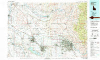
~ Boise ID topo map, 1:100000 scale, 30 X 60 Minute, Historical, 1981, updated 1981
Boise, Idaho, USGS topographic map dated 1981.
Includes geographic coordinates (latitude and longitude). This topographic map is suitable for hiking, camping, and exploring, or framing it as a wall map.
Printed on-demand using high resolution imagery, on heavy weight and acid free paper, or alternatively on a variety of synthetic materials.
Topos available on paper, Waterproof, Poly, or Tyvek. Usually shipping rolled, unless combined with other folded maps in one order.
- Product Number: USGS-5437076
- Free digital map download (high-resolution, GeoPDF): Boise, Idaho (file size: 31 MB)
- Map Size: please refer to the dimensions of the GeoPDF map above
- Weight (paper map): ca. 55 grams
- Map Type: POD USGS Topographic Map
- Map Series: HTMC
- Map Verison: Historical
- Cell ID: 67161
- Scan ID: 239357
- Imprint Year: 1981
- Woodland Tint: Yes
- Visual Version Number: 2
- Aerial Photo Year: 1977
- Edit Year: 1981
- Datum: NAD27
- Map Projection: Universal Transverse Mercator
- Map published by United States Geological Survey
- Map Language: English
- Scanner Resolution: 600 dpi
- Map Cell Name: Boise
- Grid size: 30 X 60 Minute
- Date on map: 1981
- Map Scale: 1:100000
- Geographical region: Idaho, United States
Neighboring Maps:
All neighboring USGS topo maps are available for sale online at a variety of scales.
Spatial coverage:
Topo map Boise, Idaho, covers the geographical area associated the following places:
- Montour - Star - Buckingham - Greenleaf - Roswell - Josephson - Vernon - Jenness - Boise Junction - Knowlton Heights - Hamilton Corner - Maddens - Pearl - Swartz Corner - Perkins - Letha - Emmett - Simplot - Middleton - Doles - Nampa - Highlands - Bramwell - Eagle - Homedale - Wilder - Marsing - Midway - Aikman (historical) - Rookstool Corner - Nyssa - Tiegs Corner - Black Canyon - Boise - Amsco - Ustick - Boise Hills Village - Gardena - Fischer - Collister - Howell (historical) - Owyhee Heights - Bugtown (historical) - Parma - Huston - Caldwell - Riverside - Underkoflers Corner - Plaza - Karcher Junction - Sweet - Moss - Sand Hollow - Hillcrest - Meridian - New Plymouth - Notus - Deal - Central Cove - Barber - Little Rock - South Boise (historical) - Marsh (historical) - Del Monte - Weitz - Claytonia - Palisades Corner - Sonna - Beatty - Cloverdale - Arcadia - Sunnyslope - Allendale - Apple Valley - Kings Corner - Garden City - Enrose - Horseshoe Bend
- Map Area ID: AREA4443.5-117-116
- Northwest corner Lat/Long code: USGSNW44-117
- Northeast corner Lat/Long code: USGSNE44-116
- Southwest corner Lat/Long code: USGSSW43.5-117
- Southeast corner Lat/Long code: USGSSE43.5-116
- Northern map edge Latitude: 44
- Southern map edge Latitude: 43.5
- Western map edge Longitude: -117
- Eastern map edge Longitude: -116


