
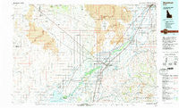
~ Blackfoot ID topo map, 1:100000 scale, 30 X 60 Minute, Historical, 1978, updated 1997
Blackfoot, Idaho, USGS topographic map dated 1978.
Includes geographic coordinates (latitude and longitude). This topographic map is suitable for hiking, camping, and exploring, or framing it as a wall map.
Printed on-demand using high resolution imagery, on heavy weight and acid free paper, or alternatively on a variety of synthetic materials.
Topos available on paper, Waterproof, Poly, or Tyvek. Usually shipping rolled, unless combined with other folded maps in one order.
- Product Number: USGS-5437072
- Free digital map download (high-resolution, GeoPDF): Blackfoot, Idaho (file size: 26 MB)
- Map Size: please refer to the dimensions of the GeoPDF map above
- Weight (paper map): ca. 55 grams
- Map Type: POD USGS Topographic Map
- Map Series: HTMC
- Map Verison: Historical
- Cell ID: 67148
- Scan ID: 239355
- Imprint Year: 1997
- Woodland Tint: Yes
- Aerial Photo Year: 1974
- Edit Year: 1978
- Datum: NAD27
- Map Projection: Universal Transverse Mercator
- Map published by United States Geological Survey
- Map Language: English
- Scanner Resolution: 600 dpi
- Map Cell Name: Blackfoot
- Grid size: 30 X 60 Minute
- Date on map: 1978
- Map Scale: 1:100000
- Geographical region: Idaho, United States
Neighboring Maps:
All neighboring USGS topo maps are available for sale online at a variety of scales.
Spatial coverage:
Topo map Blackfoot, Idaho, covers the geographical area associated the following places:
- Liberty - Peterson (historical) - Goshen - Gay - Fort Hall - Goshen Junction - Atomic City - Fullmer - Cerro Grande - Groveland - Gerrard - Aberdeen Junction - Sterling - Rising River - McDonaldville - Coffee Point - Cotton - Wapello - Clarkson - Havens - Cox - Blackfoot - Moreland - Thomas - Grandview - Scoville - Idaho Falls - Rockford - Olsen - Collins - Springfield - Kimball - Gibson - Pingree - Rouse - Riverside - Taylorville - Firth - Rose - Woodville - Taber - Basalt - Shelley - Mitchell - Aiken - Alridge
- Map Area ID: AREA43.543-113-112
- Northwest corner Lat/Long code: USGSNW43.5-113
- Northeast corner Lat/Long code: USGSNE43.5-112
- Southwest corner Lat/Long code: USGSSW43-113
- Southeast corner Lat/Long code: USGSSE43-112
- Northern map edge Latitude: 43.5
- Southern map edge Latitude: 43
- Western map edge Longitude: -113
- Eastern map edge Longitude: -112


