
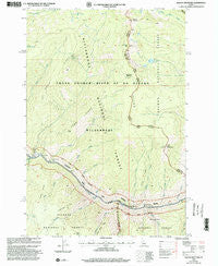
~ Waugh Mountain ID topo map, 1:24000 scale, 7.5 X 7.5 Minute, Historical, 1999, updated 2002
Waugh Mountain, Idaho, USGS topographic map dated 1999.
Includes geographic coordinates (latitude and longitude). This topographic map is suitable for hiking, camping, and exploring, or framing it as a wall map.
Printed on-demand using high resolution imagery, on heavy weight and acid free paper, or alternatively on a variety of synthetic materials.
Topos available on paper, Waterproof, Poly, or Tyvek. Usually shipping rolled, unless combined with other folded maps in one order.
- Product Number: USGS-5436302
- Free digital map download (high-resolution, GeoPDF): Waugh Mountain, Idaho (file size: 13 MB)
- Map Size: please refer to the dimensions of the GeoPDF map above
- Weight (paper map): ca. 55 grams
- Map Type: POD USGS Topographic Map
- Map Series: HTMC
- Map Verison: Historical
- Cell ID: 47746
- Scan ID: 238708
- Imprint Year: 2002
- Woodland Tint: Yes
- Aerial Photo Year: 1995
- Edit Year: 1998
- Datum: NAD27
- Map Projection: Transverse Mercator
- Map published by United States Forest Service
- Map Language: English
- Scanner Resolution: 600 dpi
- Map Cell Name: Waugh Mountain
- Grid size: 7.5 X 7.5 Minute
- Date on map: 1999
- Map Scale: 1:24000
- Geographical region: Idaho, United States
Neighboring Maps:
All neighboring USGS topo maps are available for sale online at a variety of scales.
Spatial coverage:
Topo map Waugh Mountain, Idaho, covers the geographical area associated the following places:
- Otter Creek - Waugh Mountain - Bow Creek - Lantz Rapids - Rainier Rapids - Lucky Ridge - Alder Creek - Lost Packer Lake - Fawn Ridge - Goat Point - Lost Packer Meadows - Lost Packer Peak - Phantom Creek - Legend Creek - Lantz Bar Forest Service Facility - Lantz Bar Campsite - Lantz Bar Forest Service Facility - Eakin Ridge - Lucky Creek Bar - Cottonwood Creek - Otter Ridge - Eagle Creek - Canyon Creek - Fawn Creek Bar - Fern Creek - Phantom Ridge - Spindle Creek - Lucky Creek - Little Squaw Creek - Fawn Creek - Spindle Creek Bar - Rainier Creek - Lantz Bar Recreation Site - Tag Creek - West Horse Point - Waugh Ridge - Eakin Cabin - Lantz Bar
- Map Area ID: AREA45.545.375-114.875-114.75
- Northwest corner Lat/Long code: USGSNW45.5-114.875
- Northeast corner Lat/Long code: USGSNE45.5-114.75
- Southwest corner Lat/Long code: USGSSW45.375-114.875
- Southeast corner Lat/Long code: USGSSE45.375-114.75
- Northern map edge Latitude: 45.5
- Southern map edge Latitude: 45.375
- Western map edge Longitude: -114.875
- Eastern map edge Longitude: -114.75


