
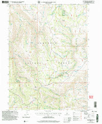
~ Trapper Peak ID topo map, 1:24000 scale, 7.5 X 7.5 Minute, Historical, 2001, updated 2006
Trapper Peak, Idaho, USGS topographic map dated 2001.
Includes geographic coordinates (latitude and longitude). This topographic map is suitable for hiking, camping, and exploring, or framing it as a wall map.
Printed on-demand using high resolution imagery, on heavy weight and acid free paper, or alternatively on a variety of synthetic materials.
Topos available on paper, Waterproof, Poly, or Tyvek. Usually shipping rolled, unless combined with other folded maps in one order.
- Product Number: USGS-5436020
- Free digital map download (high-resolution, GeoPDF): Trapper Peak, Idaho (file size: 13 MB)
- Map Size: please refer to the dimensions of the GeoPDF map above
- Weight (paper map): ca. 55 grams
- Map Type: POD USGS Topographic Map
- Map Series: HTMC
- Map Verison: Historical
- Cell ID: 45569
- Scan ID: 238538
- Imprint Year: 2006
- Woodland Tint: Yes
- Aerial Photo Year: 1998
- Datum: NAD83
- Map Projection: Universal Transverse Mercator
- Map published by United States Geological Survey
- Map published by United States Forest Service
- Map Language: English
- Scanner Resolution: 600 dpi
- Map Cell Name: Trapper Peak
- Grid size: 7.5 X 7.5 Minute
- Date on map: 2001
- Map Scale: 1:24000
- Geographical region: Idaho, United States
Neighboring Maps:
All neighboring USGS topo maps are available for sale online at a variety of scales.
Spatial coverage:
Topo map Trapper Peak, Idaho, covers the geographical area associated the following places:
- Dry Flat Spring - Bear Flat Creek - Harrington Peak - Cow-S Spring - Hudson Ridge - Telephone Canyon - Bed Spring - Telephone Spring - Ecklund Creek - Badger Mountain - Cotton Ridge - Terrells Spring - Cow Spring - Bear Flat - Cabin Spring Number Two - Freds Mound - Pickett Spring Creek - Upper Coal Pit Spring - Monument Peak - Worm Corral Hollow - Briggs Spring - Fuller Peak - First Fork Rock Creek - Bear Gulch Spring - Buttars Spring - Chicken Spring - Flatiron Mountain - Badger Mountain Spring - Cotton Creek - Picketts Upper Trough Spring - Bostetter Spring - Grouse Spring - White Stump Creek - Ledge Rock Spring - Picketts Lower Trough Spring - Hudson Ridge Spring - Cranny Spring - Second Fork Rock Creek - Bear Gulch - Pole Creek - A H Creek - Pinnacle - Dry Fork - Trapper Peak - Trail Creek - Flatiron Creek - Bostetter Forest Service Station - Pocket Spring - Fuller Pasture - Martindale Spring - Flatiron Spring - Sawmill Creek - Poison Gulch - Jones Spring - Coyote Spring - Cabin Spring - Little Fork Third Fork Rock Creek - Coyote Creek - Jarvis Spring - Bostetter Campground - Coal Pit Spring - Bostetter Pasture Spring - Cotton Spring - Cabin Spring Creek - Martindale Fork - Father and Sons Campground - Worm Corral Spring - Counting Chute Spring
- Map Area ID: AREA42.2542.125-114.25-114.125
- Northwest corner Lat/Long code: USGSNW42.25-114.25
- Northeast corner Lat/Long code: USGSNE42.25-114.125
- Southwest corner Lat/Long code: USGSSW42.125-114.25
- Southeast corner Lat/Long code: USGSSE42.125-114.125
- Northern map edge Latitude: 42.25
- Southern map edge Latitude: 42.125
- Western map edge Longitude: -114.25
- Eastern map edge Longitude: -114.125


