
~ Rocky Comfort Flat ID topo map, 1:24000 scale, 7.5 X 7.5 Minute, Historical, 2004, updated 2007
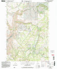
Rocky Comfort Flat, Idaho, USGS topographic map dated 2004.
Includes geographic coordinates (latitude and longitude). This topographic map is suitable for hiking, camping, and exploring, or framing it as a wall map.
Printed on-demand using high resolution imagery, on heavy weight and acid free paper, or alternatively on a variety of synthetic materials.
Topos available on paper, Waterproof, Poly, or Tyvek. Usually shipping rolled, unless combined with other folded maps in one order.
- Product Number: USGS-5434987
- Free digital map download (high-resolution, GeoPDF): Rocky Comfort Flat, Idaho (file size: 16 MB)
- Map Size: please refer to the dimensions of the GeoPDF map above
- Weight (paper map): ca. 55 grams
- Map Type: POD USGS Topographic Map
- Map Series: HTMC
- Map Verison: Historical
- Cell ID: 38365
- Scan ID: 237922
- Imprint Year: 2007
- Woodland Tint: Yes
- Aerial Photo Year: 1998
- Datum: NAD83
- Map Projection: Universal Transverse Mercator
- Map published by United States Geological Survey
- Map published by United States Forest Service
- Map Language: English
- Scanner Resolution: 600 dpi
- Map Cell Name: Rocky Comfort Flat
- Grid size: 7.5 X 7.5 Minute
- Date on map: 2004
- Map Scale: 1:24000
- Geographical region: Idaho, United States
Neighboring Maps:
All neighboring USGS topo maps are available for sale online at a variety of scales.
Spatial coverage:
Topo map Rocky Comfort Flat, Idaho, covers the geographical area associated the following places:
- Lick Creek - Gladheart Gulch - Flat Creek - Wickiup Creek - Clifton Spring - Bear Creek - Road Creek - Crooked River - Bear Creek Falls - Happy Hollow Ranch Airport (historical) - Dick Ross Creek - Ditch Creek - Steves Creek - Cows Horn Gulch - Paradise Flat - Lafferty Campground - North Hornet Mine - Cottonwood Corrals - Spring Creek - Coyote Gulch - Summit Gulch - Rocky Comfort Flat - Williams Creek - Thorn Creek - Trail Hill - Moonshine Creek - Calf Pen Gulch
- Map Area ID: AREA4544.875-116.75-116.625
- Northwest corner Lat/Long code: USGSNW45-116.75
- Northeast corner Lat/Long code: USGSNE45-116.625
- Southwest corner Lat/Long code: USGSSW44.875-116.75
- Southeast corner Lat/Long code: USGSSE44.875-116.625
- Northern map edge Latitude: 45
- Southern map edge Latitude: 44.875
- Western map edge Longitude: -116.75
- Eastern map edge Longitude: -116.625


