
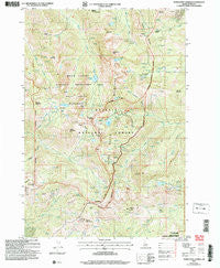
~ Purgatory Saddle ID topo map, 1:24000 scale, 7.5 X 7.5 Minute, Historical, 2004, updated 2007
Purgatory Saddle, Idaho, USGS topographic map dated 2004.
Includes geographic coordinates (latitude and longitude). This topographic map is suitable for hiking, camping, and exploring, or framing it as a wall map.
Printed on-demand using high resolution imagery, on heavy weight and acid free paper, or alternatively on a variety of synthetic materials.
Topos available on paper, Waterproof, Poly, or Tyvek. Usually shipping rolled, unless combined with other folded maps in one order.
- Product Number: USGS-5434739
- Free digital map download (high-resolution, GeoPDF): Purgatory Saddle, Idaho (file size: 17 MB)
- Map Size: please refer to the dimensions of the GeoPDF map above
- Weight (paper map): ca. 55 grams
- Map Type: POD USGS Topographic Map
- Map Series: HTMC
- Map Verison: Historical
- Cell ID: 36669
- Scan ID: 237783
- Imprint Year: 2007
- Woodland Tint: Yes
- Aerial Photo Year: 1998
- Datum: NAD83
- Map Projection: Universal Transverse Mercator
- Map published by United States Geological Survey
- Map published by United States Forest Service
- Map Language: English
- Scanner Resolution: 600 dpi
- Map Cell Name: Purgatory Saddle
- Grid size: 7.5 X 7.5 Minute
- Date on map: 2004
- Map Scale: 1:24000
- Geographical region: Idaho, United States
Neighboring Maps:
All neighboring USGS topo maps are available for sale online at a variety of scales.
Spatial coverage:
Topo map Purgatory Saddle, Idaho, covers the geographical area associated the following places:
- Smith Mountain - Lake Winifred - Curren Mountain - Horse Pasture Basin - Camp Creek - Pepperbox Hill - Oxbow Saddle - Rapid River Trail - Emmett Mountain - Six Lake Basin - Pactolian Gulch - Crystal Lake - Black Lake Campground - Black Lake - Purgatory Saddle - White Mountain - Twin Lakes - Vermilion Forest Camp - Granite Fork - Pyramid Peak - Monument Peak - Ritchie Gulch - Lost Basin - Black Imp - Jackley Mountain Lookout - Joes Gap - Casey Mountain - Lake Creek - Rock Creek - Deep Creek Trail - Echols Mountain - Paradise Flat - Rose Creek - Jackley Mountain - Iron Springs - Ruth Lake - Bear Saddle - Middle Mountain - Emerald Lake - Satan Lake - Holbrook Saddle - Casey Spring
- Map Area ID: AREA45.2545.125-116.625-116.5
- Northwest corner Lat/Long code: USGSNW45.25-116.625
- Northeast corner Lat/Long code: USGSNE45.25-116.5
- Southwest corner Lat/Long code: USGSSW45.125-116.625
- Southeast corner Lat/Long code: USGSSE45.125-116.5
- Northern map edge Latitude: 45.25
- Southern map edge Latitude: 45.125
- Western map edge Longitude: -116.625
- Eastern map edge Longitude: -116.5


