
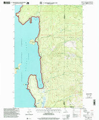
~ Priest Lake SE ID topo map, 1:24000 scale, 7.5 X 7.5 Minute, Historical, 1996, updated 1999
Priest Lake SE, Idaho, USGS topographic map dated 1996.
Includes geographic coordinates (latitude and longitude). This topographic map is suitable for hiking, camping, and exploring, or framing it as a wall map.
Printed on-demand using high resolution imagery, on heavy weight and acid free paper, or alternatively on a variety of synthetic materials.
Topos available on paper, Waterproof, Poly, or Tyvek. Usually shipping rolled, unless combined with other folded maps in one order.
- Product Number: USGS-5434701
- Free digital map download (high-resolution, GeoPDF): Priest Lake SE, Idaho (file size: 16 MB)
- Map Size: please refer to the dimensions of the GeoPDF map above
- Weight (paper map): ca. 55 grams
- Map Type: POD USGS Topographic Map
- Map Series: HTMC
- Map Verison: Historical
- Cell ID: 36439
- Scan ID: 237761
- Imprint Year: 1999
- Woodland Tint: Yes
- Aerial Photo Year: 1992
- Datum: NAD27
- Map Projection: Transverse Mercator
- Map published by United States Geological Survey
- Map published by United States Forest Service
- Map Language: English
- Scanner Resolution: 600 dpi
- Map Cell Name: Priest Lake SE
- Grid size: 7.5 X 7.5 Minute
- Date on map: 1996
- Map Scale: 1:24000
- Geographical region: Idaho, United States
Neighboring Maps:
All neighboring USGS topo maps are available for sale online at a variety of scales.
Spatial coverage:
Topo map Priest Lake SE, Idaho, covers the geographical area associated the following places:
- Steamboat Bay - Roothaan Mountain - Horton Creek - Priest Lake Incubation Channels - Priest Lake State Park Indian Creek Unit - Indian Creek Bay - Idaho Department of Lands Priest Lake Fire Protection District Station - Eightmile Island - Pinto Point - Indian Creek - Cavanaugh Bay Headquarters - Camels Prairie - Soldier Creek - Hess Point - Fenton Creek - Camels Prairie Lookout Tower - Indian Creek Campground - Cape Horn - Selkirk Mountains - Rocky Point - South Fork Hunt Creek - Priest Lake - Priest Lake State Forest - Cougar Creek - Cavanaugh Bay - Vinther-Nelson Historical Cabin - Cavanaugh Bay Airport - Fourmile Island - Hunt Creek
- Map Area ID: AREA48.62548.5-116.875-116.75
- Northwest corner Lat/Long code: USGSNW48.625-116.875
- Northeast corner Lat/Long code: USGSNE48.625-116.75
- Southwest corner Lat/Long code: USGSSW48.5-116.875
- Southeast corner Lat/Long code: USGSSE48.5-116.75
- Northern map edge Latitude: 48.625
- Southern map edge Latitude: 48.5
- Western map edge Longitude: -116.875
- Eastern map edge Longitude: -116.75


