
~ North Heglar Canyon ID topo map, 1:24000 scale, 7.5 X 7.5 Minute, Historical, 2001, updated 2006
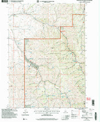
North Heglar Canyon, Idaho, USGS topographic map dated 2001.
Includes geographic coordinates (latitude and longitude). This topographic map is suitable for hiking, camping, and exploring, or framing it as a wall map.
Printed on-demand using high resolution imagery, on heavy weight and acid free paper, or alternatively on a variety of synthetic materials.
Topos available on paper, Waterproof, Poly, or Tyvek. Usually shipping rolled, unless combined with other folded maps in one order.
- Product Number: USGS-5434113
- Free digital map download (high-resolution, GeoPDF): North Heglar Canyon, Idaho (file size: 15 MB)
- Map Size: please refer to the dimensions of the GeoPDF map above
- Weight (paper map): ca. 55 grams
- Map Type: POD USGS Topographic Map
- Map Series: HTMC
- Map Verison: Historical
- Cell ID: 32375
- Scan ID: 237416
- Imprint Year: 2006
- Woodland Tint: Yes
- Aerial Photo Year: 1998
- Edit Year: 2001
- Datum: NAD83
- Map Projection: Universal Transverse Mercator
- Map published by United States Geological Survey
- Map published by United States Forest Service
- Map Language: English
- Scanner Resolution: 600 dpi
- Map Cell Name: North Heglar Canyon
- Grid size: 7.5 X 7.5 Minute
- Date on map: 2001
- Map Scale: 1:24000
- Geographical region: Idaho, United States
Neighboring Maps:
All neighboring USGS topo maps are available for sale online at a variety of scales.
Spatial coverage:
Topo map North Heglar Canyon, Idaho, covers the geographical area associated the following places:
- Young Spring - Mud Spring - Palmer Spring - Lake Fork Spring - Cedar Creek Peak - Elbow Canyon - Brush Canyon - Lower Heglar Spring - South Heglar Spring - Bruce Young Spring - Upper Fall Creek Spring - Lower Mill Canyon - Line Canyon - Moonshine Spring - Mill Canyon Spring - Indian Fork - Mine Dump Spring - Indian Spring - Upper Lake Fork Spring - Pole Canyon - Palmer Canyon - Narrow Canyon - Clint Palmer Spring - Sheep Canyon - Upper Heglar Spring - Quaking Aspen Spring - Rocky Canyon - Big Rock Canyon - Ether Park Spring - Eagle Point - Mill Canyon - Antelope Spring - Spring Canyon - Pine Canyon
- Map Area ID: AREA42.542.375-113.125-113
- Northwest corner Lat/Long code: USGSNW42.5-113.125
- Northeast corner Lat/Long code: USGSNE42.5-113
- Southwest corner Lat/Long code: USGSSW42.375-113.125
- Southeast corner Lat/Long code: USGSSE42.375-113
- Northern map edge Latitude: 42.5
- Southern map edge Latitude: 42.375
- Western map edge Longitude: -113.125
- Eastern map edge Longitude: -113


