
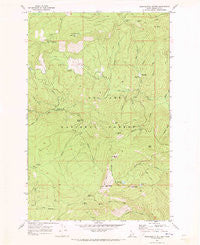
~ Monumental Buttes ID topo map, 1:24000 scale, 7.5 X 7.5 Minute, Historical, 1969, updated 1973
Monumental Buttes, Idaho, USGS topographic map dated 1969.
Includes geographic coordinates (latitude and longitude). This topographic map is suitable for hiking, camping, and exploring, or framing it as a wall map.
Printed on-demand using high resolution imagery, on heavy weight and acid free paper, or alternatively on a variety of synthetic materials.
Topos available on paper, Waterproof, Poly, or Tyvek. Usually shipping rolled, unless combined with other folded maps in one order.
- Product Number: USGS-5433786
- Free digital map download (high-resolution, GeoPDF): Monumental Buttes, Idaho (file size: 12 MB)
- Map Size: please refer to the dimensions of the GeoPDF map above
- Weight (paper map): ca. 55 grams
- Map Type: POD USGS Topographic Map
- Map Series: HTMC
- Map Verison: Historical
- Cell ID: 30060
- Scan ID: 237218
- Imprint Year: 1973
- Woodland Tint: Yes
- Aerial Photo Year: 1968
- Field Check Year: 1969
- Datum: NAD27
- Map Projection: Polyconic
- Map published by United States Geological Survey
- Map Language: English
- Scanner Resolution: 600 dpi
- Map Cell Name: Monumental Buttes
- Grid size: 7.5 X 7.5 Minute
- Date on map: 1969
- Map Scale: 1:24000
- Geographical region: Idaho, United States
Neighboring Maps:
All neighboring USGS topo maps are available for sale online at a variety of scales.
Spatial coverage:
Topo map Monumental Buttes, Idaho, covers the geographical area associated the following places:
- Upper Fishook Research Natural Area - Miller Peak - Noseeum Lake - Spokane Meadows - Polar Creek - Flatiron Knobs - Barren Hill - Little North Fork Campground - Mowich Creek - Shale Point - Jug Spring - Rutledge Creek - Rocky Run Point - Monumental Buttes - Roundtop Guard Station - Roundtop Work Center - Fortune Meadows - Ski Creek - Twin Creek Saddle - Willow Creek - South Butte - East Butte - Twin Creek Campground - N P Hill - Jug Rock - North Butte - Rocket Creek - Twin Creek - White Gravel Creek - Adair Creek - West Fork Twin Creek - Roundtop Mountain - Moses Butte - East Fork Twin Creek - Rocky Run - Forage Mountain - Old Montana Trail (historical) - Meadow Creek - Steamboat Lake - Jungle Creek
- Map Area ID: AREA47.12547-115.875-115.75
- Northwest corner Lat/Long code: USGSNW47.125-115.875
- Northeast corner Lat/Long code: USGSNE47.125-115.75
- Southwest corner Lat/Long code: USGSSW47-115.875
- Southeast corner Lat/Long code: USGSSE47-115.75
- Northern map edge Latitude: 47.125
- Southern map edge Latitude: 47
- Western map edge Longitude: -115.875
- Eastern map edge Longitude: -115.75


