
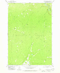
~ Magruder Mtn ID topo map, 1:24000 scale, 7.5 X 7.5 Minute, Historical, 1978, updated 1978
Magruder Mtn, Idaho, USGS topographic map dated 1978.
Includes geographic coordinates (latitude and longitude). This topographic map is suitable for hiking, camping, and exploring, or framing it as a wall map.
Printed on-demand using high resolution imagery, on heavy weight and acid free paper, or alternatively on a variety of synthetic materials.
Topos available on paper, Waterproof, Poly, or Tyvek. Usually shipping rolled, unless combined with other folded maps in one order.
- Product Number: USGS-5433440
- Free digital map download (high-resolution, GeoPDF): Magruder Mtn, Idaho (file size: 10 MB)
- Map Size: please refer to the dimensions of the GeoPDF map above
- Weight (paper map): ca. 55 grams
- Map Type: POD USGS Topographic Map
- Map Series: HTMC
- Map Verison: Historical
- Cell ID: 27254
- Scan ID: 237004
- Imprint Year: 1978
- Woodland Tint: Yes
- Aerial Photo Year: 1972
- Edit Year: 1978
- Field Check Year: 1974
- Datum: NAD27
- Map Projection: Transverse Mercator
- Map published by United States Geological Survey
- Map Language: English
- Scanner Resolution: 600 dpi
- Map Cell Name: Magruder Mountain
- Grid size: 7.5 X 7.5 Minute
- Date on map: 1978
- Map Scale: 1:24000
- Geographical region: Idaho, United States
Neighboring Maps:
All neighboring USGS topo maps are available for sale online at a variety of scales.
Spatial coverage:
Topo map Magruder Mtn, Idaho, covers the geographical area associated the following places:
- Magruder Saddle - Magruder Campground - Deadtop Mountain - Steep Gulch - Salamander Creek - Lodge Creek - Nick Creek - Haystack Saddle - Salamander Butte - Magruder Ridge - Beaver Point - Flat Creek - Lost Elk Creek - Lonely Mountain - Magruder Massacre Site - Magruder Crossing - Elk Track Lakes - Gold Pan Lake - East Fork Magruder Creek - Lonely Creek - Magruder Mountain - Kim Creek Saddle - Salamander Ridge - Ely Creek - Chuckling Creek - Short Creek - Snow Water Creek
- Map Area ID: AREA45.7545.625-114.875-114.75
- Northwest corner Lat/Long code: USGSNW45.75-114.875
- Northeast corner Lat/Long code: USGSNE45.75-114.75
- Southwest corner Lat/Long code: USGSSW45.625-114.875
- Southeast corner Lat/Long code: USGSSE45.625-114.75
- Northern map edge Latitude: 45.75
- Southern map edge Latitude: 45.625
- Western map edge Longitude: -114.875
- Eastern map edge Longitude: -114.75


