
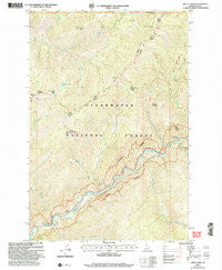
~ Holly Creek ID topo map, 1:24000 scale, 7.5 X 7.5 Minute, Historical, 2005, updated 2005
Holly Creek, Idaho, USGS topographic map dated 2005.
Includes geographic coordinates (latitude and longitude). This topographic map is suitable for hiking, camping, and exploring, or framing it as a wall map.
Printed on-demand using high resolution imagery, on heavy weight and acid free paper, or alternatively on a variety of synthetic materials.
Topos available on paper, Waterproof, Poly, or Tyvek. Usually shipping rolled, unless combined with other folded maps in one order.
- Product Number: USGS-5432594
- Free digital map download (high-resolution, GeoPDF): Holly Creek, Idaho (file size: 17 MB)
- Map Size: please refer to the dimensions of the GeoPDF map above
- Weight (paper map): ca. 55 grams
- Map Type: POD USGS Topographic Map
- Map Series: HTMC
- Map Verison: Historical
- Cell ID: 20766
- Scan ID: 236511
- Imprint Year: 2005
- Woodland Tint: Yes
- Aerial Photo Year: 1990
- Datum: NAD27
- Map Projection: Lambert Conformal Conic
- Map published by United States Forest Service
- Map Language: English
- Scanner Resolution: 600 dpi
- Map Cell Name: Holly Creek
- Grid size: 7.5 X 7.5 Minute
- Date on map: 2005
- Map Scale: 1:24000
- Geographical region: Idaho, United States
Neighboring Maps:
All neighboring USGS topo maps are available for sale online at a variety of scales.
Spatial coverage:
Topo map Holly Creek, Idaho, covers the geographical area associated the following places:
- Green Flat Campground - Hungry Point - Skookum Creek - Stanley Creek - Bald Mountain Creek - Hard Creek - Gold Meadows Creek - The Smoking Place Camp - Ninemile Rest Area - Indian Grave Camp - Fro Creek - Castle Creek - Castle Butte Camp - Holly Creek - Dutch Creek - Greensward Camp - Bald Mountain Lake - Eagle Mountain Creek - Eagle Mountain Pack Bridge - Bald Mountain - Corral Creek - Castle Butte
- Map Area ID: AREA46.546.375-115.25-115.125
- Northwest corner Lat/Long code: USGSNW46.5-115.25
- Northeast corner Lat/Long code: USGSNE46.5-115.125
- Southwest corner Lat/Long code: USGSSW46.375-115.25
- Southeast corner Lat/Long code: USGSSE46.375-115.125
- Northern map edge Latitude: 46.5
- Southern map edge Latitude: 46.375
- Western map edge Longitude: -115.25
- Eastern map edge Longitude: -115.125


