
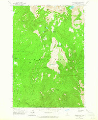
~ Hanover Mtn ID topo map, 1:24000 scale, 7.5 X 7.5 Minute, Historical, 1963, updated 1965
Hanover Mtn , Idaho, USGS topographic map dated 1963.
Includes geographic coordinates (latitude and longitude). This topographic map is suitable for hiking, camping, and exploring, or framing it as a wall map.
Printed on-demand using high resolution imagery, on heavy weight and acid free paper, or alternatively on a variety of synthetic materials.
Topos available on paper, Waterproof, Poly, or Tyvek. Usually shipping rolled, unless combined with other folded maps in one order.
- Product Number: USGS-5432392
- Free digital map download (high-resolution, GeoPDF): Hanover Mtn , Idaho (file size: 14 MB)
- Map Size: please refer to the dimensions of the GeoPDF map above
- Weight (paper map): ca. 55 grams
- Map Type: POD USGS Topographic Map
- Map Series: HTMC
- Map Verison: Historical
- Cell ID: 19231
- Scan ID: 236391
- Imprint Year: 1965
- Woodland Tint: Yes
- Aerial Photo Year: 1962
- Field Check Year: 1963
- Datum: NAD27
- Map Projection: Polyconic
- Map published by United States Geological Survey
- Map Language: English
- Scanner Resolution: 600 dpi
- Map Cell Name: Hanover Mountain
- Grid size: 7.5 X 7.5 Minute
- Date on map: 1963
- Map Scale: 1:24000
- Geographical region: Idaho, United States
Neighboring Maps:
All neighboring USGS topo maps are available for sale online at a variety of scales.
Spatial coverage:
Topo map Hanover Mtn , Idaho, covers the geographical area associated the following places:
- Grouse Creek - Moores Station - Hanover Creek - Emerald Lake - Indigo Lake - Rock Creek - Jackson Ridge - Bentz Creek - Whiskey Bills Cabin - Marten Hill - Moores Work Center - Upper Slate Lake - Slate Lake - Last Chance Gulch - Slate Lakes - Little Round Top - Upper Knob Lake - Hanover Mountain - Hagen Ridge - Rhett Meadows - Wilson Cow Camp - Rock Creek Point - Gospel Peak - Circle Creek - Round Top - Moores Lake - Wind River Meadows - Umbrella Butte - Ace Creek - Indigo Creek - Anchor Creek
- Map Area ID: AREA45.62545.5-116-115.875
- Northwest corner Lat/Long code: USGSNW45.625-116
- Northeast corner Lat/Long code: USGSNE45.625-115.875
- Southwest corner Lat/Long code: USGSSW45.5-116
- Southeast corner Lat/Long code: USGSSE45.5-115.875
- Northern map edge Latitude: 45.625
- Southern map edge Latitude: 45.5
- Western map edge Longitude: -116
- Eastern map edge Longitude: -115.875


