
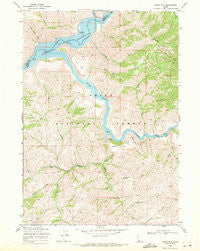
~ Grape Mtn ID topo map, 1:24000 scale, 7.5 X 7.5 Minute, Historical, 1969, updated 1971
Grape Mtn, Idaho, USGS topographic map dated 1969.
Includes geographic coordinates (latitude and longitude). This topographic map is suitable for hiking, camping, and exploring, or framing it as a wall map.
Printed on-demand using high resolution imagery, on heavy weight and acid free paper, or alternatively on a variety of synthetic materials.
Topos available on paper, Waterproof, Poly, or Tyvek. Usually shipping rolled, unless combined with other folded maps in one order.
- Product Number: USGS-5432256
- Free digital map download (high-resolution, GeoPDF): Grape Mtn, Idaho (file size: 16 MB)
- Map Size: please refer to the dimensions of the GeoPDF map above
- Weight (paper map): ca. 55 grams
- Map Type: POD USGS Topographic Map
- Map Series: HTMC
- Map Verison: Historical
- Cell ID: 18136
- Scan ID: 236309
- Imprint Year: 1971
- Woodland Tint: Yes
- Aerial Photo Year: 1963
- Edit Year: 1969
- Datum: NAD27
- Map Projection: Polyconic
- Map published by United States Geological Survey
- Map Language: English
- Scanner Resolution: 600 dpi
- Map Cell Name: Grape Mountain
- Grid size: 7.5 X 7.5 Minute
- Date on map: 1969
- Map Scale: 1:24000
- Geographical region: Idaho, United States
Neighboring Maps:
All neighboring USGS topo maps are available for sale online at a variety of scales.
Spatial coverage:
Topo map Grape Mtn, Idaho, covers the geographical area associated the following places:
- Cow Creek - South Fork Boise River - Arrowrock Reservoir - South Fork Gulch - Lambing Creek - Cold Spring Creek - Soap Creek - Willow Creek - Flat Creek - Cottonwood Creek - Dawes Creek - Corral Creek - Deadman Creek - Nibbler Creek - Jack Creek - Pury Flat - Grape Mountain - Irish Creek - Camp Creek - Nevins Creek - Lime Creek - Wood Creek - Bender Creek - Hutton Creek
- Map Area ID: AREA43.62543.5-115.875-115.75
- Northwest corner Lat/Long code: USGSNW43.625-115.875
- Northeast corner Lat/Long code: USGSNE43.625-115.75
- Southwest corner Lat/Long code: USGSSW43.5-115.875
- Southeast corner Lat/Long code: USGSSE43.5-115.75
- Northern map edge Latitude: 43.625
- Southern map edge Latitude: 43.5
- Western map edge Longitude: -115.875
- Eastern map edge Longitude: -115.75


