
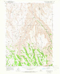
~ Grand View Peak ID topo map, 1:24000 scale, 7.5 X 7.5 Minute, Historical, 1965, updated 1966
Grand View Peak, Idaho, USGS topographic map dated 1965.
Includes geographic coordinates (latitude and longitude). This topographic map is suitable for hiking, camping, and exploring, or framing it as a wall map.
Printed on-demand using high resolution imagery, on heavy weight and acid free paper, or alternatively on a variety of synthetic materials.
Topos available on paper, Waterproof, Poly, or Tyvek. Usually shipping rolled, unless combined with other folded maps in one order.
- Product Number: USGS-5432196
- Free digital map download (high-resolution, GeoPDF): Grand View Peak, Idaho (file size: 12 MB)
- Map Size: please refer to the dimensions of the GeoPDF map above
- Weight (paper map): ca. 55 grams
- Map Type: POD USGS Topographic Map
- Map Series: HTMC
- Map Verison: Historical
- Cell ID: 18010
- Scan ID: 236278
- Imprint Year: 1966
- Woodland Tint: Yes
- Aerial Photo Year: 1961
- Field Check Year: 1965
- Datum: NAD27
- Map Projection: Polyconic
- Map published by United States Geological Survey
- Map Language: English
- Scanner Resolution: 600 dpi
- Map Cell Name: Grand View Peak
- Grid size: 7.5 X 7.5 Minute
- Date on map: 1965
- Map Scale: 1:24000
- Geographical region: Idaho, United States
Neighboring Maps:
All neighboring USGS topo maps are available for sale online at a variety of scales.
Spatial coverage:
Topo map Grand View Peak, Idaho, covers the geographical area associated the following places:
- Harrington Fork - Bluff Creek - North Willow Springs - Secret Creek - Indian Spring Creek - Pole Camp Spring - Deer Creek - Steer Basin Campground - Lucky Gulch - Magpie Basin - Sugarloaf Spring - Indian Spring - Sagehen Flats - Mud Spring - Buckbrush Flats - Pine Basin - Juniper Spring Campground (historical) - Coyote Spring - Deadeye Spring - Trail Gulch - Grand View Peak - Pine Basin Spring - Wooden Shoe Creek - Donahue Basin - Steer Basin - 330 Spring - Big Bluff Picnic Ground (historical) - Fifth Fork Rock Creek - Fourth Fork Rock Creek - Schipper Campground - Harrington Fork Picnic Area - Lincoln Reservoir - Sagehen Spring - Three Hundred Thirty Spring Picnic Ground (historical) - Jones Fork Creek - Doodlelink Creek - Little Creek - Sugarloaf - Crockett Spring - Birch Glen Picnic Ground - Wooden Shoe Spring - Wooden Shoe Butte
- Map Area ID: AREA42.37542.25-114.375-114.25
- Northwest corner Lat/Long code: USGSNW42.375-114.375
- Northeast corner Lat/Long code: USGSNE42.375-114.25
- Southwest corner Lat/Long code: USGSSW42.25-114.375
- Southeast corner Lat/Long code: USGSSE42.25-114.25
- Northern map edge Latitude: 42.375
- Southern map edge Latitude: 42.25
- Western map edge Longitude: -114.375
- Eastern map edge Longitude: -114.25


