
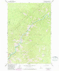
~ Fivemile Bar ID topo map, 1:24000 scale, 7.5 X 7.5 Minute, Historical, 1979, updated 1987
Fivemile Bar, Idaho, USGS topographic map dated 1979.
Includes geographic coordinates (latitude and longitude). This topographic map is suitable for hiking, camping, and exploring, or framing it as a wall map.
Printed on-demand using high resolution imagery, on heavy weight and acid free paper, or alternatively on a variety of synthetic materials.
Topos available on paper, Waterproof, Poly, or Tyvek. Usually shipping rolled, unless combined with other folded maps in one order.
- Product Number: USGS-5431965
- Free digital map download (high-resolution, GeoPDF): Fivemile Bar, Idaho (file size: 15 MB)
- Map Size: please refer to the dimensions of the GeoPDF map above
- Weight (paper map): ca. 55 grams
- Map Type: POD USGS Topographic Map
- Map Series: HTMC
- Map Verison: Historical
- Cell ID: 15421
- Scan ID: 236128
- Imprint Year: 1987
- Woodland Tint: Yes
- Photo Revision Year: 1987
- Aerial Photo Year: 1984
- Edit Year: 1987
- Field Check Year: 1979
- Datum: NAD27
- Map Projection: Transverse Mercator
- Map published by United States Geological Survey
- Map Language: English
- Scanner Resolution: 600 dpi
- Map Cell Name: Fivemile Bar
- Grid size: 7.5 X 7.5 Minute
- Date on map: 1979
- Map Scale: 1:24000
- Geographical region: Idaho, United States
Neighboring Maps:
All neighboring USGS topo maps are available for sale online at a variety of scales.
Spatial coverage:
Topo map Fivemile Bar, Idaho, covers the geographical area associated the following places:
- Tepee Creek - Mammoth Mine - Painter Point - Bear Creek - Jersey Creek - No Man Creek - Lemhi Point - Wolfe Place - Henry Moore Spring - Little Fivemile Creek - Ludwig Bar - Mammoth Mountain - Blue Bird Bar - Wilson Bar USFS Airport - Lemhi Creek - Big Blowout Creek - Little Sheepeater Lake - Painter Mine - Grizzly Gulch - Abrams Height - Gaines Bar - Blue Ridge Cabin - Rabbit Creek - Paine Creek - Mackay Bar Bridge - Fivemile Creek - Painter Bar - Tepee Gulch - Rhett Creek - Ludwig Rapids - Haney Bar - Lemhi Bar - Boise Creek - Mackay Bar Campground - Little Sheepeater Point - Fivemile Bar - Boise Bar - Rhett Creek Campground - Jackson Bar - Rocky Bar - Threemile Creek
- Map Area ID: AREA45.545.375-115.5-115.375
- Northwest corner Lat/Long code: USGSNW45.5-115.5
- Northeast corner Lat/Long code: USGSNE45.5-115.375
- Southwest corner Lat/Long code: USGSSW45.375-115.5
- Southeast corner Lat/Long code: USGSSE45.375-115.375
- Northern map edge Latitude: 45.5
- Southern map edge Latitude: 45.375
- Western map edge Longitude: -115.5
- Eastern map edge Longitude: -115.375


