
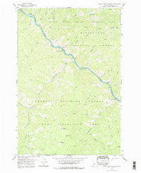
~ Devils Teeth Rapids ID topo map, 1:24000 scale, 7.5 X 7.5 Minute, Historical, 1978, updated 1979
Devils Teeth Rapids, Idaho, USGS topographic map dated 1978.
Includes geographic coordinates (latitude and longitude). This topographic map is suitable for hiking, camping, and exploring, or framing it as a wall map.
Printed on-demand using high resolution imagery, on heavy weight and acid free paper, or alternatively on a variety of synthetic materials.
Topos available on paper, Waterproof, Poly, or Tyvek. Usually shipping rolled, unless combined with other folded maps in one order.
- Product Number: USGS-5431615
- Free digital map download (high-resolution, GeoPDF): Devils Teeth Rapids, Idaho (file size: 13 MB)
- Map Size: please refer to the dimensions of the GeoPDF map above
- Weight (paper map): ca. 55 grams
- Map Type: POD USGS Topographic Map
- Map Series: HTMC
- Map Verison: Historical
- Cell ID: 12122
- Scan ID: 235913
- Imprint Year: 1979
- Woodland Tint: Yes
- Aerial Photo Year: 1972
- Edit Year: 1978
- Field Check Year: 1974
- Datum: NAD27
- Map Projection: Transverse Mercator
- Map published by United States Geological Survey
- Map Language: English
- Scanner Resolution: 600 dpi
- Map Cell Name: Devils Teeth Rapids
- Grid size: 7.5 X 7.5 Minute
- Date on map: 1978
- Map Scale: 1:24000
- Geographical region: Idaho, United States
Neighboring Maps:
All neighboring USGS topo maps are available for sale online at a variety of scales.
Spatial coverage:
Topo map Devils Teeth Rapids, Idaho, covers the geographical area associated the following places:
- Little Devils Teeth Rapids - Arctic Creek - Devils Teeth Rapids - Corey Bar Campground - Elkhorn Creek - Table Spring - Big Squaw Creek - Whimstick Creek - Disappointment Bar - Thirst Creek - Grass Mountain - Steep Creek - Elkhorn Bar Campground - Corey Bar - Smith Gulch - Devils Toe Creek - Fortune Creek - Elkhorn Bar - Salmon Falls - Chamberlain Creek - Root Creek - Harrington Creek - Hungry Creek - Dwyer Creek - McCalla Creek - Parks Creek - Patrol Point - Disappointment Creek - Big Bear Creek - Elkhorn Lookout - Tag Creek Ridge - Cub Creek - Cabin Mountain - Devils Teeth Creek - Grass Mountain Spring
- Map Area ID: AREA45.545.375-115-114.875
- Northwest corner Lat/Long code: USGSNW45.5-115
- Northeast corner Lat/Long code: USGSNE45.5-114.875
- Southwest corner Lat/Long code: USGSSW45.375-115
- Southeast corner Lat/Long code: USGSSE45.375-114.875
- Northern map edge Latitude: 45.5
- Southern map edge Latitude: 45.375
- Western map edge Longitude: -115
- Eastern map edge Longitude: -114.875


