
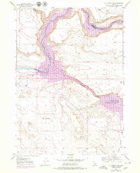
~ C J Strike Dam ID topo map, 1:24000 scale, 7.5 X 7.5 Minute, Historical, 1946, updated 1979
C J Strike Dam, Idaho, USGS topographic map dated 1946.
Includes geographic coordinates (latitude and longitude). This topographic map is suitable for hiking, camping, and exploring, or framing it as a wall map.
Printed on-demand using high resolution imagery, on heavy weight and acid free paper, or alternatively on a variety of synthetic materials.
Topos available on paper, Waterproof, Poly, or Tyvek. Usually shipping rolled, unless combined with other folded maps in one order.
- Product Number: USGS-5431008
- Free digital map download (high-resolution, GeoPDF): C J Strike Dam, Idaho (file size: 12 MB)
- Map Size: please refer to the dimensions of the GeoPDF map above
- Weight (paper map): ca. 55 grams
- Map Type: POD USGS Topographic Map
- Map Series: HTMC
- Map Verison: Historical
- Cell ID: 6567
- Scan ID: 235540
- Imprint Year: 1979
- Photo Revision Year: 1979
- Aerial Photo Year: 1976
- Edit Year: 1979
- Survey Year: 1946
- Datum: NAD27
- Map Projection: Polyconic
- Map published by United States Geological Survey
- Map Language: English
- Scanner Resolution: 600 dpi
- Map Cell Name: C J Strike Dam
- Grid size: 7.5 X 7.5 Minute
- Date on map: 1946
- Map Scale: 1:24000
- Geographical region: Idaho, United States
Neighboring Maps:
All neighboring USGS topo maps are available for sale online at a variety of scales.
Spatial coverage:
Topo map C J Strike Dam, Idaho, covers the geographical area associated the following places:
- Narrows - Canyon Creek - Rimrock Junior - Senior High School - Cove Recreation Site - Bruneau Valley - Cottonwood Campground - C J Strike Reservoir - C J Strike Wildlife Management Area - Halls Ferry (historical) - Borden Lake - Roy Johnson Ranch (historical) - C J Strike Dam - South Park - North Park - Rimrock Junior-Senior High School - Bruneau River - Ninefoot Rapids (historical) - Locust Park
- Map Area ID: AREA4342.875-116-115.875
- Northwest corner Lat/Long code: USGSNW43-116
- Northeast corner Lat/Long code: USGSNE43-115.875
- Southwest corner Lat/Long code: USGSSW42.875-116
- Southeast corner Lat/Long code: USGSSE42.875-115.875
- Northern map edge Latitude: 43
- Southern map edge Latitude: 42.875
- Western map edge Longitude: -116
- Eastern map edge Longitude: -115.875


