
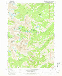
~ Boulder Chain Lakes ID topo map, 1:24000 scale, 7.5 X 7.5 Minute, Historical, 1964, updated 1981
Boulder Chain Lakes, Idaho, USGS topographic map dated 1964.
Includes geographic coordinates (latitude and longitude). This topographic map is suitable for hiking, camping, and exploring, or framing it as a wall map.
Printed on-demand using high resolution imagery, on heavy weight and acid free paper, or alternatively on a variety of synthetic materials.
Topos available on paper, Waterproof, Poly, or Tyvek. Usually shipping rolled, unless combined with other folded maps in one order.
- Product Number: USGS-5430801
- Free digital map download (high-resolution, GeoPDF): Boulder Chain Lakes, Idaho (file size: 14 MB)
- Map Size: please refer to the dimensions of the GeoPDF map above
- Weight (paper map): ca. 55 grams
- Map Type: POD USGS Topographic Map
- Map Series: HTMC
- Map Verison: Historical
- Cell ID: 4969
- Scan ID: 235414
- Imprint Year: 1981
- Woodland Tint: Yes
- Aerial Photo Year: 1957
- Field Check Year: 1964
- Datum: NAD27
- Map Projection: Polyconic
- Map published by United States Geological Survey
- Map Language: English
- Scanner Resolution: 600 dpi
- Map Cell Name: Boulder Chain Lakes
- Grid size: 7.5 X 7.5 Minute
- Date on map: 1964
- Map Scale: 1:24000
- Geographical region: Idaho, United States
Neighboring Maps:
All neighboring USGS topo maps are available for sale online at a variety of scales.
Spatial coverage:
Topo map Boulder Chain Lakes, Idaho, covers the geographical area associated the following places:
- Little Frog Lake - Slickenside Creek - Windy Devil - Gunsight Creek - Scree Lake - Boorn Lakes - Hummock Lake - Spring Basin - Willow Lake - Sapphire Lake - Castle Lake - Chamberlain Basin - Patterson Peak - Shelf Lake - Hook Lake - Island Lake - Hidden Lake - Tiny Lake - Frog Lake - Hatchet Lake - Castle Peak - Little Redfish Lake - Cove Lake - Hourglass Lake - Boulder Chain Lakes Creek - Glacier Lake - Cirque Lake - Washington Lake - Boulder Lake - Quiet Lake - Tin Cup Lake - Emerald Lake - Snow Lake - Serrate Ridge - Four Lakes Basin - Lodgepole Lake - Slide Lake - Quartzite Lake - Big Boulder Lakes - Waterdog Lake - Red Ridge - Sheep Lake - Shallow Lake - Headwall Lake - Baker Lake - Gentian Lake - Cornice Lake - Frog Lakes - Boulder Chain Lakes - The Kettles - Chamberlain Creek - Noisy Lake - White Cloud Peaks - Goat Lake - Walker Lake - Sliderock Lake - Scoop Lake - Neck Lake - Rock Lake - Bighorn Creek - Merriam Peak - Lonesome Lake
- Map Area ID: AREA44.12544-114.625-114.5
- Northwest corner Lat/Long code: USGSNW44.125-114.625
- Northeast corner Lat/Long code: USGSNE44.125-114.5
- Southwest corner Lat/Long code: USGSSW44-114.625
- Southeast corner Lat/Long code: USGSSE44-114.5
- Northern map edge Latitude: 44.125
- Southern map edge Latitude: 44
- Western map edge Longitude: -114.625
- Eastern map edge Longitude: -114.5


