
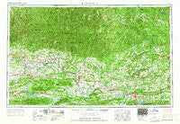
~ Russellville AR topo map, 1:250000 scale, 1 X 2 Degree, Historical, 1964
Russellville, Arkansas, USGS topographic map dated 1964.
Includes geographic coordinates (latitude and longitude). This topographic map is suitable for hiking, camping, and exploring, or framing it as a wall map.
Printed on-demand using high resolution imagery, on heavy weight and acid free paper, or alternatively on a variety of synthetic materials.
Topos available on paper, Waterproof, Poly, or Tyvek. Usually shipping rolled, unless combined with other folded maps in one order.
- Product Number: USGS-5430126
- Free digital map download (high-resolution, GeoPDF): Russellville, Arkansas (file size: 23 MB)
- Map Size: please refer to the dimensions of the GeoPDF map above
- Weight (paper map): ca. 55 grams
- Map Type: POD USGS Topographic Map
- Map Series: HTMC
- Map Verison: Historical
- Cell ID: 68997
- Scan ID: 260604
- Woodland Tint: Yes
- Field Check Year: 1953
- Datum: Unstated
- Map Projection: Transverse Mercator
- Map published by United States Army Corps of Engineers
- Map published by United States Army
- Map Language: English
- Scanner Resolution: 600 dpi
- Map Cell Name: Russellville
- Grid size: 1 X 2 Degree
- Date on map: 1964
- Map Scale: 1:250000
- Geographical region: Arkansas, United States
Neighboring Maps:
All neighboring USGS topo maps are available for sale online at a variety of scales.
Spatial coverage:
Topo map Russellville, Arkansas, covers the geographical area associated the following places:
- Walnut Grove - White Oak - Shiloh (historical) - Mountain Springs - Witter - Leigo (historical) - Hickeytown - Gayler - Brannon - Mill Creek - Begley (historical) - Hagarville - Jerusalem - Cleveland - Sweet Home - Ratcliff - Pleasant Hill - Old Neely - West (historical) - Sulphur Springs - Etna - Holman - Deer - Raspberry - Scotia - London - De Boer - Homewood - Copeland - Victor - Oppelo - Bohannon - Mars Hill - Crossroads - Big Springs - Delaney - Grandview - Brewer - Shiloh - Rex - Centerville - Fealey (historical) - Wooster - White Rock - Banner (historical) - Loafer - Mount Vernon - Otto - Treat - Crossroad - Butter Creek (historical) - New Blaine - Bethel - Alco - Divide (historical) - Latham (historical) - Old Linder (historical) - Stony Point - Venus - Lake Ridge - Vendor - Wileys Cove - Barren Hollow - Canaan - Patrick - Peanut - Boiling Springs (historical) - Havana - Hector - Altus - Sugar Grove - Fiftysix - Salem (historical) - Parma - Morrilton - South Shore Park - Falerno (historical) - Shady Grove - Moore - New Hope - Millan (historical) - Bono - Rose Creek - Sylamore - Hopewell - Hamlet - Gum Tree - Limestone - Cass - Greers Ferry - Farris Springs - Rumley - Morning Star - Archey (historical) - Prairie View - Buttermilk - Lamar - Lakeview Acres - Sunny Gap (historical) - Half Moon
- Map Area ID: AREA3635-94-92
- Northwest corner Lat/Long code: USGSNW36-94
- Northeast corner Lat/Long code: USGSNE36-92
- Southwest corner Lat/Long code: USGSSW35-94
- Southeast corner Lat/Long code: USGSSE35-92
- Northern map edge Latitude: 36
- Southern map edge Latitude: 35
- Western map edge Longitude: -94
- Eastern map edge Longitude: -92


