
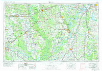
~ Helena AR topo map, 1:250000 scale, 1 X 2 Degree, Historical, 1955, updated 1978
Helena, Arkansas, USGS topographic map dated 1955.
Includes geographic coordinates (latitude and longitude). This topographic map is suitable for hiking, camping, and exploring, or framing it as a wall map.
Printed on-demand using high resolution imagery, on heavy weight and acid free paper, or alternatively on a variety of synthetic materials.
Topos available on paper, Waterproof, Poly, or Tyvek. Usually shipping rolled, unless combined with other folded maps in one order.
- Product Number: USGS-5430118
- Free digital map download (high-resolution, GeoPDF): Helena, Arkansas (file size: 18 MB)
- Map Size: please refer to the dimensions of the GeoPDF map above
- Weight (paper map): ca. 55 grams
- Map Type: POD USGS Topographic Map
- Map Series: HTMC
- Map Verison: Historical
- Cell ID: 68822
- Scan ID: 260599
- Imprint Year: 1978
- Woodland Tint: Yes
- Aerial Photo Year: 1945
- Edit Year: 1977
- Field Check Year: 1955
- Datum: Unstated
- Map Projection: Transverse Mercator
- Map published by: Military, Other
- Map Language: English
- Scanner Resolution: 600 dpi
- Map Cell Name: Helena
- Grid size: 1 X 2 Degree
- Date on map: 1955
- Map Scale: 1:250000
- Geographical region: Arkansas, United States
Neighboring Maps:
All neighboring USGS topo maps are available for sale online at a variety of scales.
Spatial coverage:
Topo map Helena, Arkansas, covers the geographical area associated the following places:
- Riverside - Hillhouse - Gospoda - Walnut Corner - Sarah - Rucks - Tocowa - Norfolk - Mellwood - Ellison - Lakeview - Fair Landing - Cessions Landing - North Stuttgart - Ragtown - Armistead - Gerlach Mill - Irby (historical) - Confederate Place - Dolton (historical) - Tarnceville - North Lexa - Moon - Brownsville - Birdie - Oak Forest - Helena Crossing - Eleanor (historical) - Park Place - Tollville - Kincade Bayou (historical) - Delta - Vineyard - Jeffries - Shepperd Crossing - Henrico (historical) - Robinsonville - Trenton - Woodville - Lenoir (historical) - Hagler - LaGrue - Belser (historical) - Childers - Culler - Immanuel - Clements (historical) - England - Crenshaw - Woodlawn Estates - Africa (historical) - Felton - Anderson Landing - Crossroad - Round Lake - Nash Corner - Roberts (historical) - Thomwall (historical) - Olena - Lynchburg - Arkabutla - Slovaktown (historical) - Sabino - Trotter Landing - Tutwiler - Oliverfried - Redfern - Dooley - Canaan - Reydell - Vance - Marks - Denton - B B Junction - Yuma (historical) - Lookout - Stover - New Salem - Holly Grove - Super (historical) - Longtown - Blue Goose (historical) - Barton - Haynes - Palestine - Stoops (historical) - Crevi (historical) - Belen - Fitch (historical) - Lincoln Terrace - Dogwood Meadows - Rescue Landing - Duncan - Kingsley Crossing - Cornerstone - Jacks Bay Landing - Plunketts - Posey - Sledge - Beck
- Map Area ID: AREA3534-92-90
- Northwest corner Lat/Long code: USGSNW35-92
- Northeast corner Lat/Long code: USGSNE35-90
- Southwest corner Lat/Long code: USGSSW34-92
- Southeast corner Lat/Long code: USGSSE34-90
- Northern map edge Latitude: 35
- Southern map edge Latitude: 34
- Western map edge Longitude: -92
- Eastern map edge Longitude: -90


