
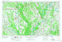
~ Helena AR topo map, 1:250000 scale, 1 X 2 Degree, Historical, 1955, updated 1967
Helena, Arkansas, USGS topographic map dated 1955.
Includes geographic coordinates (latitude and longitude). This topographic map is suitable for hiking, camping, and exploring, or framing it as a wall map.
Printed on-demand using high resolution imagery, on heavy weight and acid free paper, or alternatively on a variety of synthetic materials.
Topos available on paper, Waterproof, Poly, or Tyvek. Usually shipping rolled, unless combined with other folded maps in one order.
- Product Number: USGS-5430116
- Free digital map download (high-resolution, GeoPDF): Helena, Arkansas (file size: 16 MB)
- Map Size: please refer to the dimensions of the GeoPDF map above
- Weight (paper map): ca. 55 grams
- Map Type: POD USGS Topographic Map
- Map Series: HTMC
- Map Verison: Historical
- Cell ID: 68822
- Scan ID: 260598
- Imprint Year: 1967
- Woodland Tint: Yes
- Aerial Photo Year: 1945
- Edit Year: 1966
- Field Check Year: 1955
- Datum: Unstated
- Map Projection: Transverse Mercator
- Map published by United States Army Corps of Engineers
- Map published by United States Army
- Map Language: English
- Scanner Resolution: 600 dpi
- Map Cell Name: Helena
- Grid size: 1 X 2 Degree
- Date on map: 1955
- Map Scale: 1:250000
- Geographical region: Arkansas, United States
Neighboring Maps:
All neighboring USGS topo maps are available for sale online at a variety of scales.
Spatial coverage:
Topo map Helena, Arkansas, covers the geographical area associated the following places:
- Yoder - Ulm - Sherrill - Bayou Meto - Dundee - Lake Dick - Sellers Addition - Arkabutla - Hollywood - Reese - Redfern - Roe - Friars Point - Eudora - Turner - Walnut Grove - Gillett - Marianna - Buena Vista Lakes - Uzzett (historical) - Almyra - Hallsville - Deans Corner - North Stuttgart - Talbot Addition - Wildwood (historical) - Danforth - Kincade Bayou (historical) - Modoc - Clack - Boyd (historical) - The Oaks - Smith Corner - Burke Landing - Rena Lara - Francis - Rochdale - Evansville - Kelleys Crossing - B B Junction - Altheimer - Catron - De Soto Village - Thompson Grove - Denton - Teasdale - Heustess - Penjur - Diantha (historical) - Peppers Landing - Ladd - Villa Vale (historical) - Tyner (historical) - Eagles Nest - Stuttgart - New Hope - Nash Corner - Scaife - Armistead - Four Forks - Crowder - Knowlton - New Gascony - Duncan - Offutt Landing - Sunday (historical) - Preston Place - Ratio - Ellison - Lake Ridge - Winona - Four Groves (historical) - West Bayou (historical) - Mhoon Landing - Palmer - Rich - Becks - Tamo - Bryanville - Jacks Bay Landing - Waldstein (historical) - Varner - Ragan - Yorktown - Oak Grove - Lyon - Helena Crossing - Dolton (historical) - Dagmar - Prairie Center - New Hope (historical) - Oak Forest - West Marks - Hopper - Rich - Hazen - Carter - Stillons (historical) - Riverview - South Bend (historical)
- Map Area ID: AREA3534-92-90
- Northwest corner Lat/Long code: USGSNW35-92
- Northeast corner Lat/Long code: USGSNE35-90
- Southwest corner Lat/Long code: USGSSW34-92
- Southeast corner Lat/Long code: USGSSE34-90
- Northern map edge Latitude: 35
- Southern map edge Latitude: 34
- Western map edge Longitude: -92
- Eastern map edge Longitude: -90


