
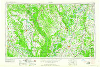
~ Helena AR topo map, 1:250000 scale, 1 X 2 Degree, Historical, 1960
Helena, Arkansas, USGS topographic map dated 1960.
Includes geographic coordinates (latitude and longitude). This topographic map is suitable for hiking, camping, and exploring, or framing it as a wall map.
Printed on-demand using high resolution imagery, on heavy weight and acid free paper, or alternatively on a variety of synthetic materials.
Topos available on paper, Waterproof, Poly, or Tyvek. Usually shipping rolled, unless combined with other folded maps in one order.
- Product Number: USGS-5430114
- Free digital map download (high-resolution, GeoPDF): Helena, Arkansas (file size: 17 MB)
- Map Size: please refer to the dimensions of the GeoPDF map above
- Weight (paper map): ca. 55 grams
- Map Type: POD USGS Topographic Map
- Map Series: HTMC
- Map Verison: Historical
- Cell ID: 68822
- Scan ID: 260597
- Woodland Tint: Yes
- Aerial Photo Year: 1945
- Field Check Year: 1955
- Datum: Unstated
- Map Projection: Transverse Mercator
- Map published by United States Army Corps of Engineers
- Map published by United States Army
- Map Language: English
- Scanner Resolution: 600 dpi
- Map Cell Name: Helena
- Grid size: 1 X 2 Degree
- Date on map: 1960
- Map Scale: 1:250000
- Geographical region: Arkansas, United States
Neighboring Maps:
All neighboring USGS topo maps are available for sale online at a variety of scales.
Spatial coverage:
Topo map Helena, Arkansas, covers the geographical area associated the following places:
- Geridge - Belser (historical) - Pine City - Saint Charles - Carter - Hushpuckena - Lake View - White Oak - Mellwood - Latour - Roseacres - Hamilton - Riverview - Letchworth - Trailwood Addition - Park Grove - Green Grove - Yorktown - Lincoln Terrace - Phenix - Lurand - Lake Ridge - Balle (historical) - LaGrue - Duncan - Parkers Corner - Yuma (historical) - Glendale (historical) - Palestine - Southwood Addition - Arkansas (historical) - Riverside - Beck - Horn Lake - Lambert - Crossroad - Meto - Prairie Union - Laconia - Lexa - Essex - Pleasant Grove - Askew (historical) - Southland - Deluce - Allendale - Farelly Lake - Sellers Addition - Sarassa - Holiday Hills - Fairfield - Hickory Plains - Hiram - Indian Bay - South Bend (historical) - Hamlin - Mount Springs Estates - Rich - Hollywood - Walnut - Eldridge - Cypress Corner - Brinkley - Hinchcliff - Glen Aubin - Hagler - Altheimer - Stover - Stoops (historical) - Tongin - Dublin - Quawpaw Village (historical) - Cottondale - Eagles Nest - Waldstein (historical) - Clack - Clarendon - Keevil - Lonoke - Barton - Kimbrough (historical) - Hugo (historical) - Beverly - Cypert - Counts - New Hope (historical) - Green River - Ferda - Wabbaseka - Stagecoach Addition - Tarry - Prairie Center - Clements (historical) - Stuttgart - Rollinson (historical) - Banks - North Lexa - Longino - Stokely - Fitch (historical)
- Map Area ID: AREA3534-92-90
- Northwest corner Lat/Long code: USGSNW35-92
- Northeast corner Lat/Long code: USGSNE35-90
- Southwest corner Lat/Long code: USGSSW34-92
- Southeast corner Lat/Long code: USGSSE34-90
- Northern map edge Latitude: 35
- Southern map edge Latitude: 34
- Western map edge Longitude: -92
- Eastern map edge Longitude: -90


