
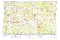
~ El Dorado AR topo map, 1:250000 scale, 1 X 2 Degree, Historical, 1953, updated 1974
El Dorado, Arkansas, USGS topographic map dated 1953.
Includes geographic coordinates (latitude and longitude). This topographic map is suitable for hiking, camping, and exploring, or framing it as a wall map.
Printed on-demand using high resolution imagery, on heavy weight and acid free paper, or alternatively on a variety of synthetic materials.
Topos available on paper, Waterproof, Poly, or Tyvek. Usually shipping rolled, unless combined with other folded maps in one order.
- Product Number: USGS-5430096
- Free digital map download (high-resolution, GeoPDF): El Dorado, Arkansas (file size: 18 MB)
- Map Size: please refer to the dimensions of the GeoPDF map above
- Weight (paper map): ca. 55 grams
- Map Type: POD USGS Topographic Map
- Map Series: HTMC
- Map Verison: Historical
- Cell ID: 76858
- Scan ID: 260587
- Imprint Year: 1974
- Woodland Tint: Yes
- Visual Version Number: 1
- Edit Year: 1966
- Field Check Year: 1953
- Datum: Unstated
- Map Projection: Transverse Mercator
- Map published by United States Geological Survey
- Map Language: English
- Scanner Resolution: 600 dpi
- Map Cell Name: El Dorado
- Grid size: 1 X 2 Degree
- Date on map: 1953
- Map Scale: 1:250000
- Geographical region: Arkansas, United States
Neighboring Maps:
All neighboring USGS topo maps are available for sale online at a variety of scales.
Spatial coverage:
Topo map El Dorado, Arkansas, covers the geographical area associated the following places:
- Bragg City - Snow Hill - Ingalls - Ogemaw - Catesville - Vaden - Beverly Hills - Harmony - Britt (historical) - Smithville - Gertrude - Camark - Eastridge Addition - Black Diamond - Kirkland - Midway - Westbrook (historical) - Louann - Forrest Bonner - Fairview - Arcadia - Three Creeks - Gum Springs - Little Bay (historical) - Plainfield - Soco - Stephens - Old Union - Lacy (historical) - Banks - Frenchport - Belton (historical) - Perrytown - Temple - Mount Vernon - Irma - Smackover - Cram - Cross Roads - Victoria - Scotland - Amity (historical) - Marsden - Wafers Crossing - Mount Pleasant - Chambersville - Craney - Red Springs - Millwood - Redland - Harlow - Roberts (historical) - Medlock - Pines Addition - Fairview - Cairo - Artex - Curtis - Missionary - Sturgis (historical) - Oak Grove - Lapile - Warner - Sardis (historical) - Blue Springs (historical) - Free Hope - Blanchard Springs - Boughton - Garlandville - College Hill - Crain City - Broad - Red Bluff - Grants - Boyd Hill - Ebenezer - Hervey - Hempstead Heights - Stillions - El Dorado - Friendship - Delhi (historical) - Huttig - McKamie - Blue Bayou - Lakeside - Unco - Kent - Cale - Jacinto - Walnut Hill - Brister - Battlefield - Wallaceburg - Cornie - Good Hope - Kress City - Liberty - Young - Woodberry
- Map Area ID: AREA3433-94-92
- Northwest corner Lat/Long code: USGSNW34-94
- Northeast corner Lat/Long code: USGSNE34-92
- Southwest corner Lat/Long code: USGSSW33-94
- Southeast corner Lat/Long code: USGSSE33-92
- Northern map edge Latitude: 34
- Southern map edge Latitude: 33
- Western map edge Longitude: -94
- Eastern map edge Longitude: -92


