
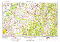
~ Blytheville AR topo map, 1:250000 scale, 1 X 2 Degree, Historical, 1956, updated 1964
Blytheville, Arkansas, USGS topographic map dated 1956.
Includes geographic coordinates (latitude and longitude). This topographic map is suitable for hiking, camping, and exploring, or framing it as a wall map.
Printed on-demand using high resolution imagery, on heavy weight and acid free paper, or alternatively on a variety of synthetic materials.
Topos available on paper, Waterproof, Poly, or Tyvek. Usually shipping rolled, unless combined with other folded maps in one order.
- Product Number: USGS-5430084
- Free digital map download (high-resolution, GeoPDF): Blytheville, Arkansas (file size: 21 MB)
- Map Size: please refer to the dimensions of the GeoPDF map above
- Weight (paper map): ca. 55 grams
- Map Type: POD USGS Topographic Map
- Map Series: HTMC
- Map Verison: Historical
- Cell ID: 68684
- Scan ID: 260579
- Imprint Year: 1964
- Woodland Tint: Yes
- Edit Year: 1964
- Field Check Year: 1956
- Datum: Unstated
- Map Projection: Transverse Mercator
- Map published by United States Army Corps of Engineers
- Map published by United States Army
- Map Language: English
- Scanner Resolution: 600 dpi
- Map Cell Name: Blytheville
- Grid size: 1 X 2 Degree
- Date on map: 1956
- Map Scale: 1:250000
- Geographical region: Arkansas, United States
Neighboring Maps:
All neighboring USGS topo maps are available for sale online at a variety of scales.
Spatial coverage:
Topo map Blytheville, Arkansas, covers the geographical area associated the following places:
- Hebron - Hickory Point - Towering Heights - Parker - Hurricane Hill - Piney Grove - Upper Nodena (historical) - Blue Goose - Center Point - Hopewell - Mount Tabor - Blytheville - Parsons - Camden Bay Subdivision - Goat City - Mousetail (historical) - Fairview - Ashport - Mount Zion - Cades - Serles - Bethlehem - Cypress - Spring Creek - Saint Paul - Luckett - Hopewell - Chaseville - Leighton - Williams Chapel - Red Walnut - Law - Hedgemoor - Calumet - Armorel - Oak Hill Subdivision - Rudolph - Hinson Springs - Double Bridges - Edith - Leighs - Tomato - Oakville - Five Forks - Pisgah - Woodhill (historical) - Needmore - Holly Grove - Key Corner - Moscow - Hookers Bend - Fulton - New Shiloh - Wellwood - Bargerton - Rosa - Quito - Brunswick - McHaney (historical) - Saulsbury - Colwick (historical) - Crucifer - Birdsong Heights - Bethel Springs - Shady Grove - Atkins (historical) - Chewalla - Cloverport - Madge - Mount Moriah - Michie - Oakview (historical) - Kerrville - Old Dunbar (historical) - New Town - Solo - Hinkle - Pearley (historical) - Central - Silerton - Keyes Point - Dogwood - Poplar Springs - Toulon - Carroll - Mount Carmel - South Fork - Selmer - Howse - Tiger Tail - Poplar Grove - Eads - Asbury - Mifflin - Ebenezer - Hickory Withe - Shiloh - Haywood Heights - Five Points - Falcon
- Map Area ID: AREA3635-90-88
- Northwest corner Lat/Long code: USGSNW36-90
- Northeast corner Lat/Long code: USGSNE36-88
- Southwest corner Lat/Long code: USGSSW35-90
- Southeast corner Lat/Long code: USGSSE35-88
- Northern map edge Latitude: 36
- Southern map edge Latitude: 35
- Western map edge Longitude: -90
- Eastern map edge Longitude: -88


