
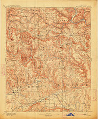
~ Mountain View AR topo map, 1:125000 scale, 30 X 30 Minute, Historical, 1894, updated 1913
Mountain View, Arkansas, USGS topographic map dated 1894.
Includes geographic coordinates (latitude and longitude). This topographic map is suitable for hiking, camping, and exploring, or framing it as a wall map.
Printed on-demand using high resolution imagery, on heavy weight and acid free paper, or alternatively on a variety of synthetic materials.
Topos available on paper, Waterproof, Poly, or Tyvek. Usually shipping rolled, unless combined with other folded maps in one order.
- Product Number: USGS-5430032
- Free digital map download (high-resolution, GeoPDF): Mountain View, Arkansas (file size: 10 MB)
- Map Size: please refer to the dimensions of the GeoPDF map above
- Weight (paper map): ca. 55 grams
- Map Type: POD USGS Topographic Map
- Map Series: HTMC
- Map Verison: Historical
- Cell ID: 66144
- Scan ID: 260551
- Imprint Year: 1913
- Survey Year: 1889
- Datum: Unstated
- Map Projection: Unstated
- Map published by United States Geological Survey
- Map Language: English
- Scanner Resolution: 600 dpi
- Map Cell Name: Mountain View
- Grid size: 30 X 30 Minute
- Date on map: 1894
- Map Scale: 1:125000
- Geographical region: Arkansas, United States
Neighboring Maps:
All neighboring USGS topo maps are available for sale online at a variety of scales.
Spatial coverage:
Topo map Mountain View, Arkansas, covers the geographical area associated the following places:
- Shiloh (historical) - Half Moon - Sandiff - Old Lexington - Kinderhook (historical) - Miller (historical) - Woodrow - Mountain View - Arkins (historical) - Parma - Pleasant Hill - Landis - Oxley - Edgemont - Brandenburg - Thola - Post Oak - Fairfield Bay - Sunny Slope - Eglantine - Plant - Everett (historical) - Budd Creek - Fiftysix - Fairview - Alco - Settlement (historical) - Palisades - Hedges (historical) - West Richwoods - Chalk (historical) - Twin Creek - Tannenbaum - Bloomington (historical) - Poe (historical) - Big Springs - Partain - Herpel - Fox - Allison - Shake Rag (historical) - Lydalisk - Choctaw - Lake Ridge - Luber - Elba - Campbell - Banner (historical) - Higden - Onia - Oga (historical) - East Richwoods - Newnata - Harness - Green Tree - Hanover - Rushing - Pee Dee - Mozart - Gayler - Flag - Greers Ferry - Lone Pine - May (historical) - Choctaw Pines - Brewer - Pekin (historical) - Clinton - Old Botkinburg - Ruddells (historical) - Arlberg - Timbo - Sylamore - Whispering Springs - Prim - Brownsville - Shirley - Turkey Creek
- Map Area ID: AREA3635.5-92.5-92
- Northwest corner Lat/Long code: USGSNW36-92.5
- Northeast corner Lat/Long code: USGSNE36-92
- Southwest corner Lat/Long code: USGSSW35.5-92.5
- Southeast corner Lat/Long code: USGSSE35.5-92
- Northern map edge Latitude: 36
- Southern map edge Latitude: 35.5
- Western map edge Longitude: -92.5
- Eastern map edge Longitude: -92


