
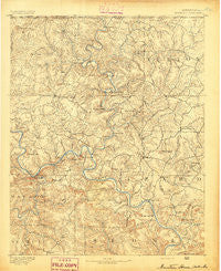
~ Mountain Home AR topo map, 1:125000 scale, 30 X 30 Minute, Historical, 1891
Mountain Home, Arkansas, USGS topographic map dated 1891.
Includes geographic coordinates (latitude and longitude). This topographic map is suitable for hiking, camping, and exploring, or framing it as a wall map.
Printed on-demand using high resolution imagery, on heavy weight and acid free paper, or alternatively on a variety of synthetic materials.
Topos available on paper, Waterproof, Poly, or Tyvek. Usually shipping rolled, unless combined with other folded maps in one order.
- Product Number: USGS-5430016
- Free digital map download (high-resolution, GeoPDF): Mountain Home, Arkansas (file size: 10 MB)
- Map Size: please refer to the dimensions of the GeoPDF map above
- Weight (paper map): ca. 55 grams
- Map Type: POD USGS Topographic Map
- Map Series: HTMC
- Map Verison: Historical
- Cell ID: 66142
- Scan ID: 260543
- Survey Year: 1890
- Datum: Unstated
- Map Projection: Unstated
- Map published by United States Geological Survey
- Map Language: English
- Scanner Resolution: 600 dpi
- Map Cell Name: Mountain Home
- Grid size: 30 X 30 Minute
- Date on map: 1891
- Map Scale: 1:125000
- Geographical region: Arkansas, United States
Neighboring Maps:
All neighboring USGS topo maps are available for sale online at a variety of scales.
Spatial coverage:
Topo map Mountain Home, Arkansas, covers the geographical area associated the following places:
- Western Hills Subdivision - Lone Rock - Fawn Park - Calico Rock - Old Buffalo - Heritage Estates - Pleasant Valley - Advance - Rodney - Forty Four - Casteel (historical) - Gassville - Wake (historical) - Lakeside Terrace - Spencer (historical) - Hepsey (historical) - Hand (historical) - Briarcliff - Elizabeth - Spring Lake Estates - Ruth - Gepp - Vidette - Iuka - Old Joe - Whiteville - Vest (historical) - Pineville - Woods Point Landing - Gorby - County Line - Mount Olive - Arkawana - Optimus - Three Brothers - Arkana - Ott - Cartney - Norfork Lake Estates - Covey (historical) - Monkey Run - Creswell - Conville (historical) - Colfax - Holiday Hills - Sycamore Spring - McPhearson - Clarkridge - Shipp - Cumi - Buffalo City - Big Flat - Timber Lake Manor - Jonesdale (historical) - Pickren Hall - Herron - Independence (historical) - Sycamore Heights - Laytonville (historical) - Berry (historical) - Shady Grove - Bennetts (historical) - Dolph - Kingswood Estates - Buford - Mallard Point - Boswell - Boyle (historical) - Mitchell - Wild Cherry - Jordan - Custer (historical) - Hand Valley - Mountain Home - Crossroads - Hopewell - Diamond Bay - Norfork Village - Midway - Wideman - Norfork - Gamaliel - Culp - Huron (historical) - Dogwood Park - Salesville - Henderson - Chastain (historical) - Argosy (historical)
- Map Area ID: AREA36.536-92.5-92
- Northwest corner Lat/Long code: USGSNW36.5-92.5
- Northeast corner Lat/Long code: USGSNE36.5-92
- Southwest corner Lat/Long code: USGSSW36-92.5
- Southeast corner Lat/Long code: USGSSE36-92
- Northern map edge Latitude: 36.5
- Southern map edge Latitude: 36
- Western map edge Longitude: -92.5
- Eastern map edge Longitude: -92


