
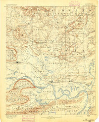
~ Morrillton AR topo map, 1:125000 scale, 30 X 30 Minute, Historical, 1892
Morrillton, Arkansas, USGS topographic map dated 1892.
Includes geographic coordinates (latitude and longitude). This topographic map is suitable for hiking, camping, and exploring, or framing it as a wall map.
Printed on-demand using high resolution imagery, on heavy weight and acid free paper, or alternatively on a variety of synthetic materials.
Topos available on paper, Waterproof, Poly, or Tyvek. Usually shipping rolled, unless combined with other folded maps in one order.
- Product Number: USGS-5429990
- Free digital map download (high-resolution, GeoPDF): Morrillton, Arkansas (file size: 8 MB)
- Map Size: please refer to the dimensions of the GeoPDF map above
- Weight (paper map): ca. 55 grams
- Map Type: POD USGS Topographic Map
- Map Series: HTMC
- Map Verison: Historical
- Cell ID: 66096
- Scan ID: 260526
- Survey Year: 1889
- Datum: Unstated
- Map Projection: Unstated
- Map published by United States Geological Survey
- Map Language: English
- Scanner Resolution: 600 dpi
- Map Cell Name: Morrilton
- Grid size: 30 X 30 Minute
- Date on map: 1892
- Map Scale: 1:125000
- Geographical region: Arkansas, United States
Neighboring Maps:
All neighboring USGS topo maps are available for sale online at a variety of scales.
Spatial coverage:
Topo map Morrillton, Arkansas, covers the geographical area associated the following places:
- Stumptoe - Northview Subdivision - Welcome - Sweet Home - Economy - Happy Bend - Dixie (historical) - Salem (historical) - Walnut Grove - Hill Creek - Mars Hill - Gold Hill - Leta (historical) - Adona - Red Hill - Mount Olive - New Dixie - Gleason - Lost Corner - Perry - Wesley Chapel - Middleton - Winrock - Kenwood - Toad Suck - Bessie (historical) - Holly Springs - Friendship - Arthur - Claude - Bethlehem - Cadron (historical) - Blackwell - Blick - Menifee - West (historical) - Perryville - Pleasant Hill - Grandview - Robertsville - Bunker Hill - North Hills Subdivision - Old Liberty (historical) - Country Estates - Springfield - Macedonia - Oak Grove - Gravel Hill - Hattieville - Overcup - Birdtown - Oppelo - Wonderview - Boiling Springs (historical) - Catholic Point - Cleveland - Moreland - Cypress Valley - Old Hickory - Hector - Lick Mountain - Pleasant Grove - Solgohachia - Nogal - Spring Meadows - McClaren - Rehms Corner - Lanty - Austin - Atkins - Cedar Creek - Homewood - Clebb (historical) - Ada - Center Ridge - Whitehall - Lewisburg - Moab (historical) - Appleton - Liberty Springs (historical) - Bigelow - Woolverton (historical) - Houston - Divide (historical) - Gobblers Point - Index (historical) - Formosa - Buttermilk - Rock Springs - Sunnyside - Saint Vincent - Rose Creek - Morrilton - Riverview - Wilson - Plumerville - Galla Rock - Jerusalem - Lone Grove - Copperas Gap (historical)
- Map Area ID: AREA35.535-93-92.5
- Northwest corner Lat/Long code: USGSNW35.5-93
- Northeast corner Lat/Long code: USGSNE35.5-92.5
- Southwest corner Lat/Long code: USGSSW35-93
- Southeast corner Lat/Long code: USGSSE35-92.5
- Northern map edge Latitude: 35.5
- Southern map edge Latitude: 35
- Western map edge Longitude: -93
- Eastern map edge Longitude: -92.5


