
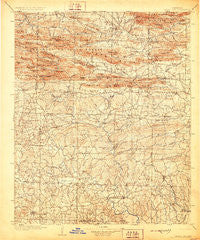
~ Caddo Gap AR topo map, 1:125000 scale, 30 X 30 Minute, Historical, 1906, updated 1928
Caddo Gap, Arkansas, USGS topographic map dated 1906.
Includes geographic coordinates (latitude and longitude). This topographic map is suitable for hiking, camping, and exploring, or framing it as a wall map.
Printed on-demand using high resolution imagery, on heavy weight and acid free paper, or alternatively on a variety of synthetic materials.
Topos available on paper, Waterproof, Poly, or Tyvek. Usually shipping rolled, unless combined with other folded maps in one order.
- Product Number: USGS-5429868
- Free digital map download (high-resolution, GeoPDF): Caddo Gap, Arkansas (file size: 10 MB)
- Map Size: please refer to the dimensions of the GeoPDF map above
- Weight (paper map): ca. 55 grams
- Map Type: POD USGS Topographic Map
- Map Series: HTMC
- Map Verison: Historical
- Cell ID: 65097
- Scan ID: 260445
- Imprint Year: 1928
- Survey Year: 1903
- Datum: Unstated
- Map Projection: Polyconic
- Map published by United States Geological Survey
- Map Language: English
- Scanner Resolution: 600 dpi
- Map Cell Name: Caddo Gap
- Grid size: 30 X 30 Minute
- Date on map: 1906
- Map Scale: 1:125000
- Geographical region: Arkansas, United States
Neighboring Maps:
All neighboring USGS topo maps are available for sale online at a variety of scales.
Spatial coverage:
Topo map Caddo Gap, Arkansas, covers the geographical area associated the following places:
- Ball (historical) - Grandfield - Murfreesboro - Muddy Fork - Nathan - Langley - Caddo Gap - Slip-Up and Hitch (historical) - Stanley (historical) - Anderson (historical) - Newhope - Green Plains - Segur - Henry - Rosboro - Daisy - Brushy (historical) - Delight - Pleasant Home (historical) - Black Springs - Elk (historical) - Dunlap (historical) - Rock Creek (historical) - Mount Moriah - Pike City - Pump Springs (historical) - Caney Valley - Pates (historical) - Cooleyville - Brocktown (historical) - Glenwood - Norman - Hattie (historical) - Hickory Station (historical) - Alf - Perkins - Kirby - Athens - Helbig (historical) - Hopewell (historical) - Center Point - Manfred - New Thompson (historical) - Maxwell (historical) - Sulphur Springs - Arp (historical) - Highland - Cox Spring - Reed - Salem - Bissell (historical) - Star of the West (historical) - Big Fork - Crawford (historical) - Slatington (historical) - Cooper (historical) - Norvelle (historical) - Rabell (historical) - Old Thompson (historical) - Kimberley - Briar - Lodi - Zebulon (historical) - Ophir - Tokio - Hopper - Plata - Albert - Corinth - Stelltown - Wright (historical) - Abner (historical) - Henry - Lissie (historical) - Roy - Stephenson (historical)
- Map Area ID: AREA34.534-94-93.5
- Northwest corner Lat/Long code: USGSNW34.5-94
- Northeast corner Lat/Long code: USGSNE34.5-93.5
- Southwest corner Lat/Long code: USGSSW34-94
- Southeast corner Lat/Long code: USGSSE34-93.5
- Northern map edge Latitude: 34.5
- Southern map edge Latitude: 34
- Western map edge Longitude: -94
- Eastern map edge Longitude: -93.5


