
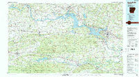
~ Russellville AR topo map, 1:100000 scale, 30 X 60 Minute, Historical, 1984, updated 1984
Russellville, Arkansas, USGS topographic map dated 1984.
Includes geographic coordinates (latitude and longitude). This topographic map is suitable for hiking, camping, and exploring, or framing it as a wall map.
Printed on-demand using high resolution imagery, on heavy weight and acid free paper, or alternatively on a variety of synthetic materials.
Topos available on paper, Waterproof, Poly, or Tyvek. Usually shipping rolled, unless combined with other folded maps in one order.
- Product Number: USGS-5429838
- Free digital map download (high-resolution, GeoPDF): Russellville, Arkansas (file size: 27 MB)
- Map Size: please refer to the dimensions of the GeoPDF map above
- Weight (paper map): ca. 55 grams
- Map Type: POD USGS Topographic Map
- Map Series: HTMC
- Map Verison: Historical
- Cell ID: 68271
- Scan ID: 260429
- Imprint Year: 1984
- Woodland Tint: Yes
- Visual Version Number: 1
- Aerial Photo Year: 1982
- Edit Year: 1984
- Datum: NAD27
- Map Projection: Universal Transverse Mercator
- Map published by United States Geological Survey
- Map Language: English
- Scanner Resolution: 600 dpi
- Map Cell Name: Russellville
- Grid size: 30 X 60 Minute
- Date on map: 1984
- Map Scale: 1:100000
- Geographical region: Arkansas, United States
Neighboring Maps:
All neighboring USGS topo maps are available for sale online at a variety of scales.
Spatial coverage:
Topo map Russellville, Arkansas, covers the geographical area associated the following places:
- Stafford - Bernice - Carden Bottoms - Prairie View - Shiloh - Revilee - Lone Pine - Alix - Pleasant Hill - Ratcliff - Effa (historical) - Kingston - Riley Creek (historical) - Millan (historical) - Norristown - London - Donald (historical) - Pisgah (historical) - Waveland - Mount Nebo - Mixon - Carolan - Sulphur Springs - Elberta - Branch - Peter Pender - Knoxville - Old Neely - Cecil - Cotton Town - Dahoma (historical) - Jamestown - Poping - Quarry Heights - Roseville - Tatetown (historical) - North Dardanelle - Scottsville - Caulksville - Sommer (historical) - Bend - Kalamazoo - Tate - Chismville - Dardanelle - Belleville - Bethel - Walnut Grove - Etna - Piney - Broomfield - Scotia - Macedonia - Havana - Driggs - Clarksville - Prosperity - Union City - Oak Grove - Taral - Mount George - Spielerville (historical) - Montana - Magazine - Denning - Cotton Town - Sills - Golden City - Carbon City - Corley - Delaware - Midway - Pisgah - Mosley - Southern Home (historical) - Casa - Paris - Bethel - Pottsville - Geren (historical) - Hartman - Birta - Cumberland (historical) - Wilkins - Chickalah - Shady Grove - Holla Bend - Booneville - Dublin - Girard (historical) - Johnson - Tokalon - Knoxville Junction - Subiaco - Meg - Hickeytown - Greenwood - Plainview - Ellsworth (historical) - Lutherville
- Map Area ID: AREA35.535-94-93
- Northwest corner Lat/Long code: USGSNW35.5-94
- Northeast corner Lat/Long code: USGSNE35.5-93
- Southwest corner Lat/Long code: USGSSW35-94
- Southeast corner Lat/Long code: USGSSE35-93
- Northern map edge Latitude: 35.5
- Southern map edge Latitude: 35
- Western map edge Longitude: -94
- Eastern map edge Longitude: -93


