
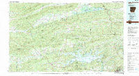
~ Lake Ouachita AR topo map, 1:100000 scale, 30 X 60 Minute, Historical, 1982, updated 1982
Lake Ouachita, Arkansas, USGS topographic map dated 1982.
Includes geographic coordinates (latitude and longitude). This topographic map is suitable for hiking, camping, and exploring, or framing it as a wall map.
Printed on-demand using high resolution imagery, on heavy weight and acid free paper, or alternatively on a variety of synthetic materials.
Topos available on paper, Waterproof, Poly, or Tyvek. Usually shipping rolled, unless combined with other folded maps in one order.
- Product Number: USGS-5429820
- Free digital map download (high-resolution, GeoPDF): Lake Ouachita, Arkansas (file size: 32 MB)
- Map Size: please refer to the dimensions of the GeoPDF map above
- Weight (paper map): ca. 55 grams
- Map Type: POD USGS Topographic Map
- Map Series: HTMC
- Map Verison: Historical
- Cell ID: 67801
- Scan ID: 260420
- Imprint Year: 1982
- Woodland Tint: Yes
- Aerial Photo Year: 1980
- Edit Year: 1982
- Datum: NAD27
- Map Projection: Universal Transverse Mercator
- Map published by United States Geological Survey
- Map Language: English
- Scanner Resolution: 600 dpi
- Map Cell Name: Lake Ouachita
- Grid size: 30 X 60 Minute
- Date on map: 1982
- Map Scale: 1:100000
- Geographical region: Arkansas, United States
Neighboring Maps:
All neighboring USGS topo maps are available for sale online at a variety of scales.
Spatial coverage:
Topo map Lake Ouachita, Arkansas, covers the geographical area associated the following places:
- Ava - Opal - Fannie - Highland - Hog Jaw - Steve - Nebraska (historical) - Pencil Bluff - Harvey - Oakwood (historical) - Parks - Hollis - Fir (historical) - Sweethome - Wing - Mountain Valley - Hurricane Grove - Mount Ida - Blue Ball - Gibbs - Owley - Olio - Joplin - Whitetown - Royal - Gladstone (historical) - Bucksville (historical) - Crystal Springs - Gilkey (historical) - Mount Tabor - Gaston - Rubie - Union Hill - Briggsville - Redbird (historical) - Ozark Lithia - Hamilton - Nimrod - Chalybeate Springs - Mountain Pine - Bear - Washita - Ruble - Deberrie - Hawes - Young Gravelly - Oden - Cedar Creek - Little Texas - Bonanza Springs (historical) - Lena (historical) - Onyx - Jessieville - Mimosa - Blakely - Cedar Glades (historical) - Shark - Piney - Union Hill - Hot Springs - Avant - Fourche Valley - Story - Aly - Silver - Plainview - Liberty - Fourche Junction - Pleasant Hill - Little Fir Landing - Euclid Heights - Wards Crossing - Waltreak - Nola - Sims - Buck Knob - Crystal Springs Landing - Mauldin - Huddleston - Buddys Landing - Chula - Cardiff - Rover - Blue Springs - Bluffton - Forester - Chasewood Landing - Gravelly - Stillwater - Cherry Hill - Pine Ridge
- Map Area ID: AREA3534.5-94-93
- Northwest corner Lat/Long code: USGSNW35-94
- Northeast corner Lat/Long code: USGSNE35-93
- Southwest corner Lat/Long code: USGSSW34.5-94
- Southeast corner Lat/Long code: USGSSE34.5-93
- Northern map edge Latitude: 35
- Southern map edge Latitude: 34.5
- Western map edge Longitude: -94
- Eastern map edge Longitude: -93


