
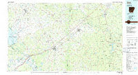
~ Hope AR topo map, 1:100000 scale, 30 X 60 Minute, Historical, 1986, updated 1986
Hope, Arkansas, USGS topographic map dated 1986.
Includes geographic coordinates (latitude and longitude). This topographic map is suitable for hiking, camping, and exploring, or framing it as a wall map.
Printed on-demand using high resolution imagery, on heavy weight and acid free paper, or alternatively on a variety of synthetic materials.
Topos available on paper, Waterproof, Poly, or Tyvek. Usually shipping rolled, unless combined with other folded maps in one order.
- Product Number: USGS-5429812
- Free digital map download (high-resolution, GeoPDF): Hope, Arkansas (file size: 22 MB)
- Map Size: please refer to the dimensions of the GeoPDF map above
- Weight (paper map): ca. 55 grams
- Map Type: POD USGS Topographic Map
- Map Series: HTMC
- Map Verison: Historical
- Cell ID: 67682
- Scan ID: 260416
- Imprint Year: 1986
- Woodland Tint: Yes
- Aerial Photo Year: 1983
- Edit Year: 1986
- Datum: NAD27
- Map Projection: Universal Transverse Mercator
- Planimetric: Yes
- Map published by United States Geological Survey
- Map Language: English
- Scanner Resolution: 600 dpi
- Map Cell Name: Hope
- Grid size: 30 X 60 Minute
- Date on map: 1986
- Map Scale: 1:100000
- Geographical region: Arkansas, United States
Neighboring Maps:
All neighboring USGS topo maps are available for sale online at a variety of scales.
Spatial coverage:
Topo map Hope, Arkansas, covers the geographical area associated the following places:
- Mount Olive (historical) - Millwood - Wallaceburg - Yancy - Academy (historical) - Perrytown - Oak Grove - McNab - Coler - Curtis - Sardis (historical) - Red Springs - Sayre - Smithton - Barringer - Compton (historical) - Nevark - Lackland (historical) - Dills Mills - Rocky Mound - Foss (historical) - Keyton (historical) - Sprudel - Hills of Hope - Mendenhall - Kilgore (historical) - Barham - Gurdon - Morris - Bodcaw - Wakefield (historical) - Cummings Springs - Register (historical) - Clow - Hope - Bluff City - Sutton - New Mount Moriah (historical) - Chapel Hill - Columbus - Midway - Crossroads - Red Hill - Harmony - Smithton (historical) - Washington - Park Addition - Britt (historical) - Westbrook (historical) - Orton - De Ann - Azor - Schaal - Holcomb Addition - Wafers Crossing - Redland - Pisgah - Paup - Forest Hills - Dave - Belton (historical) - Dolph (historical) - Allbrook - Waterloo - Buck Range - Saratoga - Pleasant Hill - Pines Addition - Irma - Georgetown Addition - Billstown - Ames - Willisville - Rosston - Laneburg - Dotson Station (historical) - Bellair - Schooley - Centerville - McCaskill - Amity (historical) - Piney Grove - Red Bluff - Clipper - Thrasher (historical) - Gum Grove - Clayton (historical) - Dunlap - Guernsey - Unity - Frisco Addition - Prescott - Brisbane (historical) - Dotson - Gunter Addition - Iron Springs - Okay - Temperanceville - Cale - Green Acres
- Map Area ID: AREA3433.5-94-93
- Northwest corner Lat/Long code: USGSNW34-94
- Northeast corner Lat/Long code: USGSNE34-93
- Southwest corner Lat/Long code: USGSSW33.5-94
- Southeast corner Lat/Long code: USGSSE33.5-93
- Northern map edge Latitude: 34
- Southern map edge Latitude: 33.5
- Western map edge Longitude: -94
- Eastern map edge Longitude: -93


