
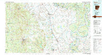
~ Dumas AR topo map, 1:100000 scale, 30 X 60 Minute, Historical, 1986, updated 1989
Dumas, Arkansas, USGS topographic map dated 1986.
Includes geographic coordinates (latitude and longitude). This topographic map is suitable for hiking, camping, and exploring, or framing it as a wall map.
Printed on-demand using high resolution imagery, on heavy weight and acid free paper, or alternatively on a variety of synthetic materials.
Topos available on paper, Waterproof, Poly, or Tyvek. Usually shipping rolled, unless combined with other folded maps in one order.
- Product Number: USGS-5429790
- Free digital map download (high-resolution, GeoPDF): Dumas, Arkansas (file size: 27 MB)
- Map Size: please refer to the dimensions of the GeoPDF map above
- Weight (paper map): ca. 55 grams
- Map Type: POD USGS Topographic Map
- Map Series: HTMC
- Map Verison: Historical
- Cell ID: 67444
- Scan ID: 260404
- Imprint Year: 1989
- Woodland Tint: Yes
- Aerial Photo Year: 1984
- Edit Year: 1986
- Datum: NAD27
- Map Projection: Universal Transverse Mercator
- Map published by United States Geological Survey
- Map Language: English
- Scanner Resolution: 600 dpi
- Map Cell Name: Dumas
- Grid size: 30 X 60 Minute
- Date on map: 1986
- Map Scale: 1:100000
- Geographical region: Arkansas, United States
Neighboring Maps:
All neighboring USGS topo maps are available for sale online at a variety of scales.
Spatial coverage:
Topo map Dumas, Arkansas, covers the geographical area associated the following places:
- Warrenton - Yukon - Feenyville - Reedville - College Heights - Dermott - Cornerville - Relfs Bluff - Red Fork - Medford (historical) - Flynn - Rye - Jade (historical) - Champion (historical) - Tennessee - Kelso - Mills - Lake Vista - Dumas - Littles (historical) - Eutaw Landing - Rock Springs - McArthur - Rosedale - New Hope - Catfish Point Landing - Oakdale (historical) - Terrene Landing - Corinth - Constance (historical) - Omega - Killin - Paradise (historical) - Bolivar Landing - Trippe Junction - Benoit - Forkland - Rough and Ready (historical) - Yancopin - Meroney - Choctaw Village (historical) - Ozmont Bluff (historical) - Bowser (historical) - Zellner (historical) - Oakwoods (historical) - Red Neck (historical) - Lacy (historical) - White River - Winchester - Wargo Landing - Mound Landing - Eutaw - Calhoun - Annover (historical) - Back Gate - Garrett Bridge - Barkada - Rohwer - Bolivar - Benzal - Gould - Brandon - Pickens - Rotan - Lamont - Enon - Green Hill - Coleman - Lucca Landing - Scott - Wilmar - Shiloh - Pea Ridge - Avery - Glendale - Sixteenth Section - Rose Hill - Star City - Halley Junction - Watson - Plantersville - Baxter - Little Garnett - Jeter (historical) - Mitchellville - McGehee - Hopedale (historical) - Niblett Landing - Scrouge Out (historical) - Parma (historical) - Hannah - Home Landing - Old Union (historical) - Bogota (historical) - Selma - Riverton Landing - Old Piney (historical) - Garnett - Masonville - Halley
- Map Area ID: AREA3433.5-92-91
- Northwest corner Lat/Long code: USGSNW34-92
- Northeast corner Lat/Long code: USGSNE34-91
- Southwest corner Lat/Long code: USGSSW33.5-92
- Southeast corner Lat/Long code: USGSSE33.5-91
- Northern map edge Latitude: 34
- Southern map edge Latitude: 33.5
- Western map edge Longitude: -92
- Eastern map edge Longitude: -91


