
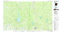
~ De Queen AR topo map, 1:100000 scale, 30 X 60 Minute, Historical, 1986, updated 1986
De Queen, Arkansas, USGS topographic map dated 1986.
Includes geographic coordinates (latitude and longitude). This topographic map is suitable for hiking, camping, and exploring, or framing it as a wall map.
Printed on-demand using high resolution imagery, on heavy weight and acid free paper, or alternatively on a variety of synthetic materials.
Topos available on paper, Waterproof, Poly, or Tyvek. Usually shipping rolled, unless combined with other folded maps in one order.
- Product Number: USGS-5429784
- Free digital map download (high-resolution, GeoPDF): De Queen, Arkansas (file size: 23 MB)
- Map Size: please refer to the dimensions of the GeoPDF map above
- Weight (paper map): ca. 55 grams
- Map Type: POD USGS Topographic Map
- Map Series: HTMC
- Map Verison: Historical
- Cell ID: 67391
- Scan ID: 260401
- Imprint Year: 1986
- Woodland Tint: Yes
- Aerial Photo Year: 1980
- Edit Year: 1986
- Datum: NAD27
- Map Projection: Universal Transverse Mercator
- Planimetric: Yes
- Map published by United States Geological Survey
- Map Language: English
- Scanner Resolution: 600 dpi
- Map Cell Name: De Queen
- Grid size: 30 X 60 Minute
- Date on map: 1986
- Map Scale: 1:100000
- Geographical region: Arkansas, United States
Neighboring Maps:
All neighboring USGS topo maps are available for sale online at a variety of scales.
Spatial coverage:
Topo map De Queen, Arkansas, covers the geographical area associated the following places:
- Cedar Glade (historical) - Atwood - Geneva - Valley Ridge (historical) - Buffalo (historical) - Pryor Ridge (historical) - Provo - Red Hill (historical) - Avon - Watson - Sunshine (historical) - Glover - Bethel Chapel - Oak Hill (historical) - Smyrna (historical) - Old Cove - Wickes - Hartley - Hochatown - Galena - Broken Bow - Ultima Thule - Shady - Lone Valley - Old Euclid (historical) - Fairview - Antioch (historical) - Bog Springs - Dierks - Bluff Springs (historical) - Gillham - Mineola - Pleasant Hill - Faulkner Springs - Duckett - Mount Carmel - Bethel - Rough Edge (historical) - Steel Junction - McCauley - Process City - New Moon (historical) - Union - Hatton - Oak Hill - Plunketville - Battle Hill (historical) - Blanchard (historical) - Bethany - Midway (historical) - Mineral - Oak Grove - Bethel (historical) - Grannis - De Queen - Vandervoort - Holly Grove - North Pole - Duckett Ford - Smithville - Cross Trails (historical) - King - Lebanon - Golden - Martha (historical) - Baker Springs - Kellum - Red Wing - Cove - Roff (historical) - Pullman - Cheatham - Stephens Gap - Mouton (historical) - Dial (historical) - Saline (historical) - Hatfield - Antrey (historical) - Tiner - Nani-chito - Davis Ford - Battiest - Chapel Hill - Mount Herman - Old Union (historical) - Clayton Spur (historical) - Eagletown - Cedar Hill (historical) - Burg - Umpire - Buck Creek Landing - Sherwood - Euclid - Antimony (historical) - Beachton - Oreb (historical)
- Map Area ID: AREA34.534-95-94
- Northwest corner Lat/Long code: USGSNW34.5-95
- Northeast corner Lat/Long code: USGSNE34.5-94
- Southwest corner Lat/Long code: USGSSW34-95
- Southeast corner Lat/Long code: USGSSE34-94
- Northern map edge Latitude: 34.5
- Southern map edge Latitude: 34
- Western map edge Longitude: -95
- Eastern map edge Longitude: -94


