
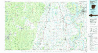
~ Crossett AR topo map, 1:100000 scale, 30 X 60 Minute, Historical, 1986, updated 1986
Crossett, Arkansas, USGS topographic map dated 1986.
Includes geographic coordinates (latitude and longitude). This topographic map is suitable for hiking, camping, and exploring, or framing it as a wall map.
Printed on-demand using high resolution imagery, on heavy weight and acid free paper, or alternatively on a variety of synthetic materials.
Topos available on paper, Waterproof, Poly, or Tyvek. Usually shipping rolled, unless combined with other folded maps in one order.
- Product Number: USGS-5429780
- Free digital map download (high-resolution, GeoPDF): Crossett, Arkansas (file size: 23 MB)
- Map Size: please refer to the dimensions of the GeoPDF map above
- Weight (paper map): ca. 55 grams
- Map Type: POD USGS Topographic Map
- Map Series: HTMC
- Map Verison: Historical
- Cell ID: 67364
- Scan ID: 260399
- Imprint Year: 1986
- Woodland Tint: Yes
- Aerial Photo Year: 1984
- Edit Year: 1986
- Datum: NAD27
- Map Projection: Universal Transverse Mercator
- Planimetric: Yes
- Map published by United States Geological Survey
- Map Language: English
- Scanner Resolution: 600 dpi
- Map Cell Name: Crossett
- Grid size: 30 X 60 Minute
- Date on map: 1986
- Map Scale: 1:100000
- Geographical region: Arkansas, United States
Neighboring Maps:
All neighboring USGS topo maps are available for sale online at a variety of scales.
Spatial coverage:
Topo map Crossett, Arkansas, covers the geographical area associated the following places:
- Youngstown - Gulledge - Moody (historical) - Lewis - Ashwood (historical) - Oakhurst Addition - Eudora - Reeves (historical) - Elon (historical) - Vaucluse - Silver Lake (historical) - Ladelle - Parkdale - Bovine - Troy (historical) - Panther Forest - Rawls - Post Oak - Berlin - Milo - Lloyd - Fairview - Paducah (historical) - Glen Allan - Montrose - Wallace - Negro Bend (historical) - Jordan (historical) - Scipio - Lakeport - Crossett - Hampton - Ashton - Kimball - Forest Park Addition - Foote - McGinty - Wilmot - Berea - Point Comfort - Leota - Geddie - White - Lone Sasafras (historical) - Chicot - Empire - Hunt - Promised Land - Beech Creek Crossing - Brighton - Pugh - Valley Junction - Carpenter - Riley - Lakehall - Phelan (historical) - Unity - Marathon - Bayou Macon (historical) - Princeton (historical) - Myrtle Grove - Yellow Bayou - Gum Corner - Fountain Hill - Boeuf - Hickory Ridge - Trafalgar - Kaplin (historical) - Whitlow Junction - Dewey - Matoka (historical) - Harwood - Donbey - Linsey (historical) - Mount Pleasant - Bowman - Red Leaf - Millers Chapel - Shives - Maxey (historical) - Scaife (historical) - Alhambra - Metcalfe - Sterling (historical) - Macon Lake - Deep Elm - Chatham - West Crossett - Hudspeth - Lacey - Snyder - Beulah - Lake Washington (historical) - Jennie - Whitlow - Lake Village - Byrne City - Elmwood - Grand Lake - Avon
- Map Area ID: AREA33.533-92-91
- Northwest corner Lat/Long code: USGSNW33.5-92
- Northeast corner Lat/Long code: USGSNE33.5-91
- Southwest corner Lat/Long code: USGSSW33-92
- Southeast corner Lat/Long code: USGSSE33-91
- Northern map edge Latitude: 33.5
- Southern map edge Latitude: 33
- Western map edge Longitude: -92
- Eastern map edge Longitude: -91


