
~ Cherokee Village AR topo map, 1:100000 scale, 30 X 60 Minute, Historical, 1983, updated 1983
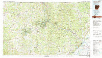
Cherokee Village, Arkansas, USGS topographic map dated 1983.
Includes geographic coordinates (latitude and longitude). This topographic map is suitable for hiking, camping, and exploring, or framing it as a wall map.
Printed on-demand using high resolution imagery, on heavy weight and acid free paper, or alternatively on a variety of synthetic materials.
Topos available on paper, Waterproof, Poly, or Tyvek. Usually shipping rolled, unless combined with other folded maps in one order.
- Product Number: USGS-5429774
- Free digital map download (high-resolution, GeoPDF): Cherokee Village, Arkansas (file size: 29 MB)
- Map Size: please refer to the dimensions of the GeoPDF map above
- Weight (paper map): ca. 55 grams
- Map Type: POD USGS Topographic Map
- Map Series: HTMC
- Map Verison: Historical
- Cell ID: 67281
- Scan ID: 260396
- Imprint Year: 1983
- Woodland Tint: Yes
- Aerial Photo Year: 1980
- Edit Year: 1983
- Datum: NAD27
- Map Projection: Universal Transverse Mercator
- Map published by United States Geological Survey
- Map Language: English
- Scanner Resolution: 600 dpi
- Map Cell Name: Cherokee Village
- Grid size: 30 X 60 Minute
- Date on map: 1983
- Map Scale: 1:100000
- Geographical region: Arkansas, United States
Neighboring Maps:
All neighboring USGS topo maps are available for sale online at a variety of scales.
Spatial coverage:
Topo map Cherokee Village, Arkansas, covers the geographical area associated the following places:
- Horseshoe Bend - Belview - Birdell - Armstrong - Peach (historical) - Sage - King - Brockwell - Melbourne - Lunenburg - New Liberty - Cherokee Village - Annieville - Kittle - Draft (historical) - Yadkin (historical) - Band Mill - Herrick (historical) - Opposition (historical) - Ravenden Springs - Union - Balboa (historical) - Sloan - Fryatt - Lorine - Stuart - Watervalley (historical) - Calamine - Cornertown - Agnos - Hamil - Dalton - Fairview - LaCrosse - Palestine - Saddle - Wheeling - Frickenger (historical) - Ash Flat - Oconee (historical) - Lauratown - Sturkie - Zion - Mount Pleasant - Franklin - Myron - Sidney - Frisbee (historical) - Poughkeepsie - Canton (historical) - Glencoe - Reed (historical) - Wenstead (historical) - Powhatan - Richwoods - Wiseman - Bone Town - Knob Creek - Violet Hill - Wirth - Oxford - Many Islands - Shady Grove - Center - Dunn - Lynn - Lone Star - Bridgeport (historical) - Imboden - Noland - Woodland Hills - Sellers Store - Kingsville (historical) - Kings Mills (historical) - Stoney Point - Needmore - Hardy - Moko - Bexar - Davidsonville (historical) - Highland - Jumbo - Ozark Acres - Denton - Amateur (historical) - Black Rock - Camp - Sitka - Ingram - Jesup - Flint Springs - Morriston - Newburg - Nelsonville - Hidden Valley - Byron - Smithville - Baker Ford - Evening Shade - Jett (historical)
- Map Area ID: AREA36.536-92-91
- Northwest corner Lat/Long code: USGSNW36.5-92
- Northeast corner Lat/Long code: USGSNE36.5-91
- Southwest corner Lat/Long code: USGSSW36-92
- Southeast corner Lat/Long code: USGSSE36-91
- Northern map edge Latitude: 36.5
- Southern map edge Latitude: 36
- Western map edge Longitude: -92
- Eastern map edge Longitude: -91


